IMAGES TAKEN NEAR TO
Anston Avenue, SHEFFIELD, S26 6LD
Introduction
This page details the photographs taken nearby to Anston Avenue, S26 6LD by members of the Geograph project.
The Geograph project started in 2005 with the aim of publishing, organising and preserving representative images for every square kilometre of Great Britain, Ireland and the Isle of Man.

There are currently over 7.5m images from over14,400 individuals and you can help contribute to the project by visiting https://www.geograph.org.uk
Image Map
Images are licensed for reuse under creativecommons.org/licenses/by-sa/2.0
Notes
- Clicking on the map will re-center to the selected point.
- The higher the marker number, the further away the image location is from the centre of the postcode.
Image Listing (15 Images Found)
Images are licensed for reuse under creativecommons.org/licenses/by-sa/2.0
Image
Details
Distance
1
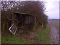
Tumbledown allotment shack
Rear of Wesley Road North allotments looking west towards Wales High School
Image: © Karl Smt
Taken: 10 Feb 2013
0.19 miles
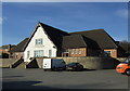
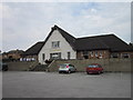
2
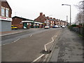
Kiveton Park - Youth and Community Centre
Image: © Alan Heardman
Taken: 27 Jan 2009
0.21 miles
3

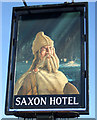
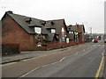
The Saxon Hotel, Kiveton Park
A Sam Smith's public house.
Image: © Ian S
Taken: 12 Aug 2012
0.22 miles
4
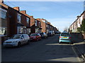
Kiveton Park - Junction of Wesley Road and Station Road
Image: © Alan Heardman
Taken: 27 Jan 2009
0.22 miles
5
The Saxon Hotel, Kiveton Park
A Sam Smith's public house.
Image: © Ian S
Taken: 12 Aug 2012
0.22 miles