IMAGES TAKEN NEAR TO
Parklands View, SHEFFIELD, S26 2GW
Introduction
This page details the photographs taken nearby to Parklands View, S26 2GW by members of the Geograph project.
The Geograph project started in 2005 with the aim of publishing, organising and preserving representative images for every square kilometre of Great Britain, Ireland and the Isle of Man.

There are currently over 7.5m images from over14,400 individuals and you can help contribute to the project by visiting https://www.geograph.org.uk
Image Map
Images are licensed for reuse under creativecommons.org/licenses/by-sa/2.0
Notes
- Clicking on the map will re-center to the selected point.
- The higher the marker number, the further away the image location is from the centre of the postcode.
Image Listing (5 Images Found)
Images are licensed for reuse under creativecommons.org/licenses/by-sa/2.0
Image
Details
Distance
1
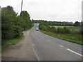
Mansfield Road (A618) - Approaching the A57 Roundabout
Image: © Alan Heardman
Taken: 9 Sep 2008
0.11 miles
2
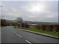
Bus stop on Mansfield Road, Aston, Rotherham
On the horizon the industrial area of Wales.
Image: © Steve Fareham
Taken: 2 Dec 2009
0.15 miles
3
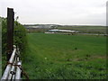
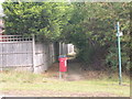
Chained Gate and Field
This field is in marked contrast to the industrial use the land on the opposite side of the road is put. Most of the units in the distance are in the next square south at Waleswood.
Image: © Michael Patterson
Taken: 2 May 2006
0.16 miles