IMAGES TAKEN NEAR TO
Bookers Lane, SHEFFIELD, S25 1ZX
Introduction
This page details the photographs taken nearby to Bookers Lane, S25 1ZX by members of the Geograph project.
The Geograph project started in 2005 with the aim of publishing, organising and preserving representative images for every square kilometre of Great Britain, Ireland and the Isle of Man.

There are currently over 7.5m images from over14,400 individuals and you can help contribute to the project by visiting https://www.geograph.org.uk
Image Map
Images are licensed for reuse under creativecommons.org/licenses/by-sa/2.0
Notes
- Clicking on the map will re-center to the selected point.
- The higher the marker number, the further away the image location is from the centre of the postcode.
Image Listing (9 Images Found)
Images are licensed for reuse under creativecommons.org/licenses/by-sa/2.0
Image
Details
Distance
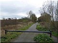
1
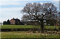
Common Farm, Dinnington
.
Common Farm near Dinnington, seen from near the southern terminus of the Old Mineral Line, a disused railway trail that runs between Dinnington and Thurcroft in South Yorkshire.
Image: © Mike Nield
Taken: 22 Dec 2016
0.00 miles
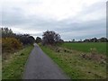
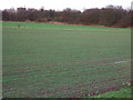
2
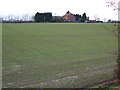
Common Farm.
Taken from the disused railway embankment.
Image: © John Poyser
Taken: 5 Jan 2007
0.05 miles
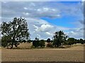
3
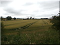
Crop Field near Common Farm
Pictured from a slipway path which allows access on foot to the disused mineral line from Todwick Road. Common Farm itself is partially visible on the right of picture.
Image: © Jonathan Clitheroe
Taken: 16 Jul 2016
0.11 miles
4
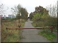
The Old Mineral Line Trail
The southern end of The Old Mineral Line Trail where the footpath meets the lane to Common Farm. This was once the point of Laughton South Junction on the Dinnington to Thurcroft to Braithwell Junction railway.
Image: © Dave Taylor
Taken: 30 Oct 2009
0.15 miles
7
Hedgerow between stubble fields
Viewed through a gap in the hedge on Common Road
Image: © Graham Hogg
Taken: 26 Sep 2022
0.22 miles
8
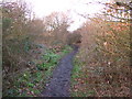
Railway path.
The footpath along the disused railway,both sides are very overgrown.
Image: © John Poyser
Taken: 5 Jan 2007
0.23 miles
9
Railway embankment.
The disused railway,just behind are the roofs of the industrial estate.
Image: © John Poyser
Taken: 5 Jan 2007
0.24 miles