IMAGES TAKEN NEAR TO
St. Barnabas Lane, SHEFFIELD, S2 4TG
Introduction
This page details the photographs taken nearby to St. Barnabas Lane, S2 4TG by members of the Geograph project.
The Geograph project started in 2005 with the aim of publishing, organising and preserving representative images for every square kilometre of Great Britain, Ireland and the Isle of Man.

There are currently over 7.5m images from over14,400 individuals and you can help contribute to the project by visiting https://www.geograph.org.uk
Image Map (Loading...)


Getting Data...Please wait
Leaflet Map data © OpenStreetMap
Images are licensed for reuse under creativecommons.org/licenses/by-sa/2.0
Notes
- Clicking on the map will re-center to the selected point.
- The higher the marker number, the further away the image location is from the centre of the postcode.
Image Listing (221 Images Found)
Images are licensed for reuse under creativecommons.org/licenses/by-sa/2.0
Image
Details
Distance
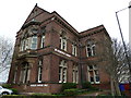
1
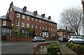
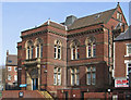
An early April walk along the London Road 6
Houses opposite Highfield Library
Image: © Basher Eyre
Taken: 3 Apr 2012
0.02 miles
2
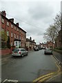
An early April walk along the London Road 10
Looking into St Barnabas Road.
Image: © Basher Eyre
Taken: 3 Apr 2012
0.02 miles
5
An early April walk along the London Road 7
Image: © Basher Eyre
Taken: 3 Apr 2012
0.04 miles
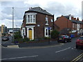
6
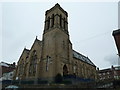
Former church of St Barnabas
Taken in Highfield Place.
Image: © Basher Eyre
Taken: 3 Apr 2012
0.04 miles
7
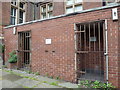
An early April walk along the London Road 3
Unsurprisingly closed!
Image: © Basher Eyre
Taken: 3 Apr 2012
0.04 miles
9
Heeley - Highfield Library
For an alternative view, please see Image
Image: © Dave Bevis
Taken: 5 Mar 2014
0.05 miles
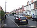
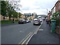
10
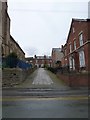
Path from Highfield Place to St Barnabas Road
Image: © Basher Eyre
Taken: 3 Apr 2012
0.05 miles