IMAGES TAKEN NEAR TO
Park Grange Drive, SHEFFIELD, S2 3BU
Introduction
This page details the photographs taken nearby to Park Grange Drive, S2 3BU by members of the Geograph project.
The Geograph project started in 2005 with the aim of publishing, organising and preserving representative images for every square kilometre of Great Britain, Ireland and the Isle of Man.

There are currently over 7.5m images from over14,400 individuals and you can help contribute to the project by visiting https://www.geograph.org.uk
Image Map
Images are licensed for reuse under creativecommons.org/licenses/by-sa/2.0
Notes
- Clicking on the map will re-center to the selected point.
- The higher the marker number, the further away the image location is from the centre of the postcode.
Image Listing (32 Images Found)
Images are licensed for reuse under creativecommons.org/licenses/by-sa/2.0
Image
Details
Distance
1
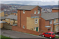
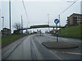
New Housing, Norfolk Park
Newly built housing with a spectacular view off Park Grange Road. From this vantage point the topography of Sheffield can be clearly seen; the Sheaf Valley runs north-east to meet the Don Valley which runs in a broadly west - east loop.
Image: © Stephen McKay
Taken: 25 Feb 2007
0.10 miles
2
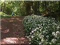
Wild Garlic in Jervis Lum, Norfolk Park
Jervis Lum is a wooded dell to the south of Norfolk Park. It was compulsorily purchased from The Duke of Norfolk by Sheffield City Council in 1956.
Image: © Neil Theasby
Taken: 30 May 2010
0.11 miles
3
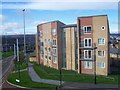
Park Grange Mount
Modern housing at the junction of Park Grange Mount and Park Grange Road.
Image: © Martin Speck
Taken: 18 Oct 2008
0.12 miles
4
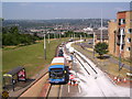
Park Grange Road in 2013
Looking down Park Grange Road from a footbridge near to Park Grange Mount. The tram-lines are closed due to maintenance work. Also see Stephen McKay's 2007 photograph, Image
Image: © Martin Speck
Taken: 18 Jul 2013
0.13 miles
5
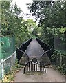
Footbridge in Jervis Lum (Woodland)
Iron bridge crossing a surprisingly deep gorge near the southern end of Norfolk Park. Lum (or 'lumb') refers to a slow-moving stream through a cleft or ravine often joining a pond or lake.
Image: © Jonathan Clitheroe
Taken: 9 Oct 2019
0.14 miles
6
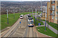
Park Grange Road, Sheffield
Looking down into the Sheaf Valley from the vantage point of a footbridge in the Norfolk Park area, as a tram heads for Halfway up the steep hill. Note the new mosque, standing out prominently in the bottom of the valley.
Image: © Stephen McKay
Taken: 25 Feb 2007
0.14 miles
7
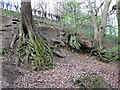
Exposed roots
I was fascinated by the roots of these trees, exposed by erosion of the soil on the steep banks of Jervis Lum (clough).
Image: © Stephen Craven
Taken: 5 Apr 2012
0.14 miles
9
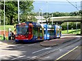
Sheffield Supertram at the Park Grange stop
Image: © Graham Hogg
Taken: 24 Aug 2010
0.14 miles
10
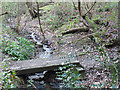
Norfolk Park: footbridge
A small footbridge over the stream in Jervis Lum, that leads to a footpath to Park Grange Road.
Image: © Stephen Craven
Taken: 5 Apr 2012
0.15 miles