IMAGES TAKEN NEAR TO
Farm Road, SHEFFIELD, S2 2TP
Introduction
This page details the photographs taken nearby to Farm Road, S2 2TP by members of the Geograph project.
The Geograph project started in 2005 with the aim of publishing, organising and preserving representative images for every square kilometre of Great Britain, Ireland and the Isle of Man.

There are currently over 7.5m images from over14,400 individuals and you can help contribute to the project by visiting https://www.geograph.org.uk
Image Map
Images are licensed for reuse under creativecommons.org/licenses/by-sa/2.0
Notes
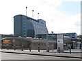
- Clicking on the map will re-center to the selected point.
- The higher the marker number, the further away the image location is from the centre of the postcode.
Image Listing (173 Images Found)
Images are licensed for reuse under creativecommons.org/licenses/by-sa/2.0
Image
Details
Distance
1
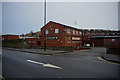
Farm Road Sports and Social Club
Farm Road, Sheffield.
Image: © Ian S
Taken: 20 Jan 2018
0.02 miles
2
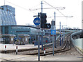
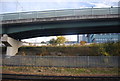
Supertram alongside City College
The start of the viaduct that takes the tram lines away from the city centre and up towards Herdings Park. There appears to be a southbound-only tram stop alongside the newly rebuilt college. See also Image
Image: © Stephen Craven
Taken: 5 Apr 2012
0.03 miles
3
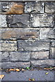
Benchmark on wall on west side of Queens Road
Ordnance Survey cut mark benchmark described on the Bench Mark Database at http://www.bench-marks.org.uk/bm39580
Image: © Roger Templeman
Taken: 19 Sep 2011
0.04 miles
4
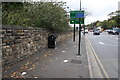
Queens Road, looking north
There is an OS benchmark Image on the wall
Image: © Roger Templeman
Taken: 19 Sep 2011
0.04 miles
6
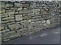
Sheffield, Queens Road wall
Ordnance Survey cut mark benchmark on stone in rough wall on east side of Queens Road. The mark was levelled at 57.2719m above Newlyn datum and verified in 1961. More information on the mark may be found on the Bench Mark Database at http://www.bench-marks.org.uk/bm34636
Image: © Roger Templeman
Taken: 10 Jun 2010
0.05 miles
7
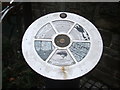
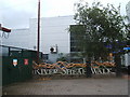
River Sheaf Walk, plaque, Sheffield
The walk starts at the junction of Queens Road and St Mary's Road. Like so many city rivers the course of this is sometime hard to follow, as it disappears under buildings
Image: © Peter Barr
Taken: 26 Aug 2009
0.06 miles
8
Start of "River Sheaf Walk" , Sheffield
Descriptive plaque at Imagedescribes this walk, and the area and its industrial past
Image: © Peter Barr
Taken: 26 Aug 2009
0.06 miles
9
City College, rebuilt
It is difficult to place this photo precisely on the map, which still seems to show the old layout of buildings on the site. The new college, which sits roughly astride the gridline, was completed in 2010 - see Image
Image: © Stephen Craven
Taken: 5 Apr 2012
0.06 miles
10
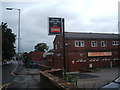
Farm Road Sports and Social Club, Farm Road, Sheffield
Image: © Peter Barr
Taken: 26 Aug 2009
0.07 miles