IMAGES TAKEN NEAR TO
Ravencarr Road, SHEFFIELD, S2 1SR
Introduction
This page details the photographs taken nearby to Ravencarr Road, S2 1SR by members of the Geograph project.
The Geograph project started in 2005 with the aim of publishing, organising and preserving representative images for every square kilometre of Great Britain, Ireland and the Isle of Man.

There are currently over 7.5m images from over14,400 individuals and you can help contribute to the project by visiting https://www.geograph.org.uk
Image Map
Images are licensed for reuse under creativecommons.org/licenses/by-sa/2.0
Notes
- Clicking on the map will re-center to the selected point.
- The higher the marker number, the further away the image location is from the centre of the postcode.
Image Listing (7 Images Found)
Images are licensed for reuse under creativecommons.org/licenses/by-sa/2.0
Image
Details
Distance
1
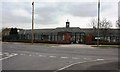
Standhouse Centre
This former primary school was built in 1934 to serve the newly developed council housing estate.
Image: © Keith Pitchforth
Taken: 15 Apr 2010
0.15 miles
2
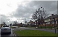
Ring road roadworks at Sheffield Manor
Image: © Steve Fareham
Taken: 26 Mar 2015
0.20 miles
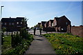
5
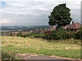
View from Manor Wood with backs of houses on Raynald Road
Image: © Neil Theasby
Taken: 2 Aug 2010
0.23 miles
6
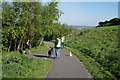
Sheffield Park Run, Manor Fields Park, Sheffield
Image: © Ian S
Taken: 3 May 2014
0.23 miles
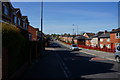
7
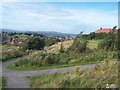
Fringes of Manor Fields Park
Tarmac footpaths following the eastern contours of the park. The roofs on the right belong to dwellings on Raynald Road.
Image: © Jonathan Clitheroe
Taken: 6 Sep 2012
0.24 miles