IMAGES TAKEN NEAR TO
Queen Mary Road, SHEFFIELD, S2 1HR
Introduction
This page details the photographs taken nearby to Queen Mary Road, S2 1HR by members of the Geograph project.
The Geograph project started in 2005 with the aim of publishing, organising and preserving representative images for every square kilometre of Great Britain, Ireland and the Isle of Man.

There are currently over 7.5m images from over14,400 individuals and you can help contribute to the project by visiting https://www.geograph.org.uk
Image Map (Loading...)


Getting Data...Please wait
Leaflet Map data © OpenStreetMap
Images are licensed for reuse under creativecommons.org/licenses/by-sa/2.0
Notes
- Clicking on the map will re-center to the selected point.
- The higher the marker number, the further away the image location is from the centre of the postcode.
Image Listing (22 Images Found)
Images are licensed for reuse under creativecommons.org/licenses/by-sa/2.0
Image
Details
Distance
1
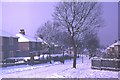
Cary Road, Manor Estate, Sheffield, 1969
Looking down Cary Road from Fitzhubert Road, Winter 1969, houses on both sides since demolished and new housing built, street layout and trees remain unchanged.
Image: © mega monty
Taken: Unknown
0.06 miles
2
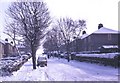
Cary Road, Manor Estate, Sheffield, 1969
Looking up Cary Road from Queen Mary Road, Winter 1969, houses on both sides since demolished and new housing built, street layout and trees remain unchanged
Image: © mega monty
Taken: Unknown
0.07 miles
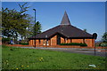
4

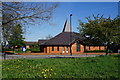
St. Swithun's Church
One of three churches in the Sheffield Manor Parish
Image: © Graham Hogg
Taken: 6 Apr 2012
0.13 miles

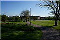
8
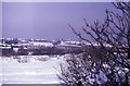
Manor Fields, Sheffield, Winter 1969
Manor Fields with Manor Castle on the Horizon
Image: © mega monty
Taken: Unknown
0.14 miles
10
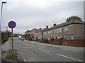
Wulfric Road, Manor
A residential road off City Road, a little way below Manor Top. The no stopping sign in the foreground has presumably been reversed. The housing in the right foreground has the narrow, deep windows characteristic of much Sheffield council housing.
Image: © Richard Vince
Taken: 10 Jul 2013
0.14 miles