IMAGES TAKEN NEAR TO
Mill Lane, SHEFFIELD, S21 3UZ
Introduction
This page details the photographs taken nearby to Mill Lane, S21 3UZ by members of the Geograph project.
The Geograph project started in 2005 with the aim of publishing, organising and preserving representative images for every square kilometre of Great Britain, Ireland and the Isle of Man.

There are currently over 7.5m images from over14,400 individuals and you can help contribute to the project by visiting https://www.geograph.org.uk
Image Map
Images are licensed for reuse under creativecommons.org/licenses/by-sa/2.0
Notes
- Clicking on the map will re-center to the selected point.
- The higher the marker number, the further away the image location is from the centre of the postcode.
Image Listing (34 Images Found)
Images are licensed for reuse under creativecommons.org/licenses/by-sa/2.0
Image
Details
Distance
1
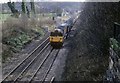
Northbound coal train
A northbound coal train hauled by 58036 heads north along the old road and is about to pass under the main road at Renishaw by the Golf Course.
Image: © roger geach
Taken: 17 Mar 1989
0.10 miles
2
Old Line of Chesterfield Canal
The canal passed to the west of Birley & Boiley farms it followed the 55metre contour rejoining the route north east of Boiley Farm. This section became redundant due to the building of a railway in 1892 which rerouted the canal.
Image: © John Jennings
Taken: 20 Feb 2012
0.14 miles
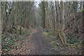
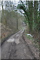
3
Woodland track towards Renishaw
The track on the right runs parallel to and west of the old railway line. The path leaving to the left crosses the line to join the Cuckoo Way looping to Renishaw (as named on the 1:25,000 map). On a first visit the paths were quite confusing. Coming from the college at Spinkhill, I had to cross the railway and recross to join the looping Cucckoo Way path to the left. The railway was in a deep cutting, I am not sure whether there is access to that trail from this point.
Image: © Andrew Hill
Taken: 26 May 2011
0.16 miles
4
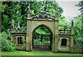
The Gothick Archway
A former entrance lodge to Renishaw Hall, with the Sitwell Arms in the pediment
Image: © Kevin Waterhouse
Taken: 30 May 2008
0.16 miles
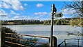
5
Rabbit Lane
Lane from Spinkhill Lane to Birley Farm
Image: © John Jennings
Taken: 20 Feb 2012
0.16 miles
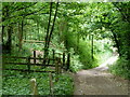
6
Impeded path near Renishaw
We didn't walk that way
Image: © Chris Morgan
Taken: 23 Feb 2022
0.16 miles
7
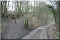
Path to Trans Pennine Trail
Off Rabbit Lane
Image: © John Jennings
Taken: 20 Feb 2012
0.17 miles
8
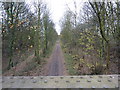
Trans Pennine Trail
Exhausted runner by bench. North of Renishaw.
Image: © Peter Barr
Taken: 28 Nov 2011
0.18 miles
9
Bridle Path to Westthorpe Fields
From Rabbit Lane to Westthorpe fields
Image: © John Jennings
Taken: 20 Feb 2012
0.18 miles
10
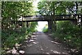
Box girder bridge over the Transpennine Trail
East of Birley Farm
Image: © Neil Theasby
Taken: 4 Oct 2012
0.19 miles