IMAGES TAKEN NEAR TO
Brindley Court, SHEFFIELD, S21 1HE
Introduction
This page details the photographs taken nearby to Brindley Court, S21 1HE by members of the Geograph project.
The Geograph project started in 2005 with the aim of publishing, organising and preserving representative images for every square kilometre of Great Britain, Ireland and the Isle of Man.

There are currently over 7.5m images from over14,400 individuals and you can help contribute to the project by visiting https://www.geograph.org.uk
Image Map
Images are licensed for reuse under creativecommons.org/licenses/by-sa/2.0
Notes
- Clicking on the map will re-center to the selected point.
- The higher the marker number, the further away the image location is from the centre of the postcode.
Image Listing (86 Images Found)
Images are licensed for reuse under creativecommons.org/licenses/by-sa/2.0
Image
Details
Distance
1
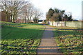
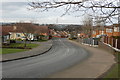
Cuckoo Way Towpath At the top of Quarry Road
There was a bridge that crossed the canal at the top of Quarry Road.
Image: © John Jennings
Taken: 30 Jan 2012
0.04 miles
2
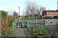
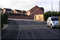
Cuckoo way At Walford Road
Chesterfield Canal Preservation Society are working to reopen the canal, Walford Road a new obstruction will have to be bridged.
Image: © John Jennings
Taken: 30 Jan 2012
0.04 miles
3
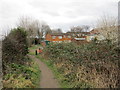
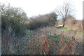
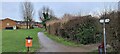
Approaching Walford Road
The path is the towpath of the former Chesterfield Canal. At this point the canal has been overtaken by vegetation and Walford Road would be a major obstacle should the canal ever re-open.
Image: © Jonathan Thacker
Taken: 5 Feb 2016
0.04 miles
6
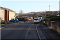
Cuckoo way at Walford Road looking west
Image: © John Jennings
Taken: 30 Jan 2012
0.05 miles
10
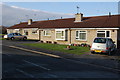
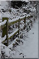
Path beside former Chesterfield Canal
The canal is long disused and dry at this point, behind the hedge.
Image: © Chris Morgan
Taken: 8 Mar 2021
0.07 miles