IMAGES TAKEN NEAR TO
Manor Road, SHEFFIELD, S21 1BU
Introduction
This page details the photographs taken nearby to Manor Road, S21 1BU by members of the Geograph project.
The Geograph project started in 2005 with the aim of publishing, organising and preserving representative images for every square kilometre of Great Britain, Ireland and the Isle of Man.

There are currently over 7.5m images from over14,400 individuals and you can help contribute to the project by visiting https://www.geograph.org.uk
Image Map
Images are licensed for reuse under creativecommons.org/licenses/by-sa/2.0
Notes
- Clicking on the map will re-center to the selected point.
- The higher the marker number, the further away the image location is from the centre of the postcode.
Image Listing (42 Images Found)
Images are licensed for reuse under creativecommons.org/licenses/by-sa/2.0
Image
Details
Distance
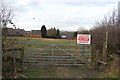
6
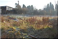
Site of Manor Farm
Awaiting development for new houses
Image: © John Jennings
Taken: 16 Jan 2012
0.09 miles
8
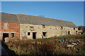
Derelict Stables Manor Farm
All that remains of Manor Farm. The site has planning Permission for House Development.
Image: © John Jennings
Taken: 16 Jan 2012
0.12 miles

10
Entrance to 1 Acre Field
This field has just changed hand and outline Planning permission has been sought to build approx. 500 house on this and adjacent land.
Image: © John Jennings
Taken: 2 Feb 2012
0.13 miles