IMAGES TAKEN NEAR TO
Middle Ox Gardens, SHEFFIELD, S20 4SR
Introduction
This page details the photographs taken nearby to Middle Ox Gardens, S20 4SR by members of the Geograph project.
The Geograph project started in 2005 with the aim of publishing, organising and preserving representative images for every square kilometre of Great Britain, Ireland and the Isle of Man.

There are currently over 7.5m images from over14,400 individuals and you can help contribute to the project by visiting https://www.geograph.org.uk
Image Map
Images are licensed for reuse under creativecommons.org/licenses/by-sa/2.0
Notes
- Clicking on the map will re-center to the selected point.
- The higher the marker number, the further away the image location is from the centre of the postcode.
Image Listing (6 Images Found)
Images are licensed for reuse under creativecommons.org/licenses/by-sa/2.0
Image
Details
Distance
1
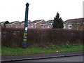
Pipe on the B6053
This is one of three pipes, the others are nearby, they all have Coal Authority labels on, but not sure of their purpose. It can't be dangerous as there isn't a barrier in front.
It has been suggested they vent methane from old mine workings.
Image: © John Poyser
Taken: 3 Jan 2007
0.15 miles
2
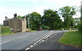
Rotherham Road past the end of Windmill Greenway
Looking south along the B6053, before it drops downhill in the direction of Eckington.
Image: © Andrew Hill
Taken: 30 May 2011
0.18 miles
3
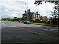
House on Rotherham Road
Top of Beighton Hill, or Windmill Hill.
Image: © Peter Barr
Taken: 11 Jul 2012
0.19 miles
4
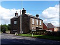
Covert Side
Large detached house on Rotherham Road, Windmill Hill.
Image: © Graham Hogg
Taken: 28 Aug 2012
0.19 miles
5
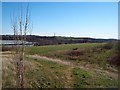
Disused Land at Oxclose
An area of undeveloped land which is situated close to a large Morrisons supermarket and other industrial units. The picture was taken from the Oxclose Park roundabout.
Image: © Jonathan Clitheroe
Taken: 6 Mar 2012
0.19 miles
6

County Boundary
The footpath from Windmill Hill towards Killamarsh marks the county boundary between Derbyshire and South Yorkshire.
Image: © John Poyser
Taken: 3 Jan 2007
0.21 miles