IMAGES TAKEN NEAR TO
Ullswater Avenue, SHEFFIELD, S20 4GX
Introduction
This page details the photographs taken nearby to Ullswater Avenue, S20 4GX by members of the Geograph project.
The Geograph project started in 2005 with the aim of publishing, organising and preserving representative images for every square kilometre of Great Britain, Ireland and the Isle of Man.

There are currently over 7.5m images from over14,400 individuals and you can help contribute to the project by visiting https://www.geograph.org.uk
Image Map
Images are licensed for reuse under creativecommons.org/licenses/by-sa/2.0
Notes
- Clicking on the map will re-center to the selected point.
- The higher the marker number, the further away the image location is from the centre of the postcode.
Image Listing (4 Images Found)
Images are licensed for reuse under creativecommons.org/licenses/by-sa/2.0
Image
Details
Distance
1
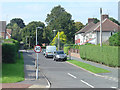
School Avenue
Tween-war development off Rotherham Road
Image: © Alan Murray-Rust
Taken: 19 Sep 2008
0.17 miles
2
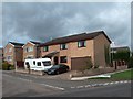
Welbury Gardens, Mosborough, Sheffield 20
Image: © Neil Theasby
Taken: 21 Sep 2011
0.18 miles
3
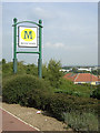
Morrisons, Halfway
Signboard on Eckington Way, looking over the Rother Valley
Image: © Alan Murray-Rust
Taken: 19 Sep 2008
0.21 miles
4
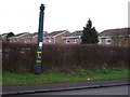
Pipe on the B6053
This is one of three pipes, the others are nearby, they all have Coal Authority labels on, but not sure of their purpose. It can't be dangerous as there isn't a barrier in front.
It has been suggested they vent methane from old mine workings.
Image: © John Poyser
Taken: 3 Jan 2007
0.24 miles