IMAGES TAKEN NEAR TO
Nether Oak View, SHEFFIELD, S20 2PW
Introduction
This page details the photographs taken nearby to Nether Oak View, S20 2PW by members of the Geograph project.
The Geograph project started in 2005 with the aim of publishing, organising and preserving representative images for every square kilometre of Great Britain, Ireland and the Isle of Man.

There are currently over 7.5m images from over14,400 individuals and you can help contribute to the project by visiting https://www.geograph.org.uk
Image Map
Images are licensed for reuse under creativecommons.org/licenses/by-sa/2.0
Notes
- Clicking on the map will re-center to the selected point.
- The higher the marker number, the further away the image location is from the centre of the postcode.
Image Listing (6 Images Found)
Images are licensed for reuse under creativecommons.org/licenses/by-sa/2.0
Image
Details
Distance
1
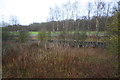
Scrubland between railway lines at Westthorpe Run-Round
Image: © Roger Templeman
Taken: 26 Mar 2016
0.18 miles
3
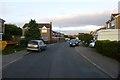
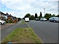
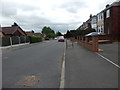
Collingbourne Avenue
Typical late 20th century suburban estate. With the usual problem of excessive car ownership.
Image: © David Lally
Taken: 17 Sep 2016
0.19 miles
4
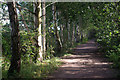
Former Railway, near Sothall
There was once a tangle of railways through this part of the Rother Valley. This was the Great Central line between Nottingham and Sheffield; the parallel Midland line remains as an important freight route between Chesterfield and Rotherham. This section now forms part of the Trans-Pennine trail.
Image: © Stephen McKay
Taken: 26 Aug 2007
0.21 miles
6
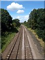
Railway in the Rother Valley
Seen from the footbridge that carries the Trans Pennine Trail over the railway. This is a freight line but does occasionally get used by passenger trains diverted from the main line between Sheffield and Chesterfield.
Image: © Graham Hogg
Taken: 28 Aug 2012
0.24 miles