IMAGES TAKEN NEAR TO
S18 6LE
Introduction
This page details the photographs taken nearby to S18 6LE by members of the Geograph project.
The Geograph project started in 2005 with the aim of publishing, organising and preserving representative images for every square kilometre of Great Britain, Ireland and the Isle of Man.

There are currently over 7.5m images from over14,400 individuals and you can help contribute to the project by visiting https://www.geograph.org.uk
Image Map
Images are licensed for reuse under creativecommons.org/licenses/by-sa/2.0
Notes
- Clicking on the map will re-center to the selected point.
- The higher the marker number, the further away the image location is from the centre of the postcode.
Image Listing (20 Images Found)
Images are licensed for reuse under creativecommons.org/licenses/by-sa/2.0
Image
Details
Distance
1
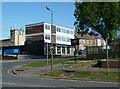
Corner of Stonelow Road and Green Lane, Dronfield
Green Lane forms the B6158 rising north from the town centre, with a mix of shops, houses and industry on this section.
Image: © Andrew Hill
Taken: 24 May 2011
0.07 miles
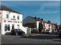
5
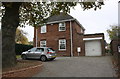
#2 Park Avenue viewed from Green Lane
There is an OS benchmark Image on the right hand side of the attached garage
Image: © Roger Templeman
Taken: 6 Nov 2018
0.14 miles
6
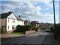
Dronfield - Cecil Avenue
Looking towards Snape Hill Lane.
Image: © Alan Heardman
Taken: 18 Oct 2007
0.14 miles
7
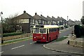
Booth and Fisher bus at Dronfield -1979
Booth and Fisher was a family bus business operating out of Halfway near Sheffield. By this time it had already been sold (in 1975) to the South Yorkshire Passenger Transport Executive, as indicated by the 4-digit fleet number, although it was some time before all vehicles were repainted into SYPTE brown and cream livery.
TCY662 was bought second hand from South Wales Transport in 1972, and is an AEC Reliance with Marshall bodywork, new in 1962.
This is one of a series of views featuring buses in the 60s, 70s, and 80s. http://www.geograph.org.uk/search.php?i=137652761
Image: © Alan Murray-Rust
Taken: 12 Nov 1978
0.14 miles
8
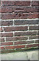
Benchmark on the garage of #2 Park Avenue
Ordnance Survey cut mark benchmark levelled at 139.696m above Newlyn Datum
Image: © Roger Templeman
Taken: 6 Nov 2018
0.15 miles
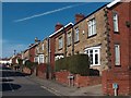
9
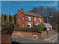
House on corner of Summerfield Road and Green Lane, Dronfield
Image: © Neil Theasby
Taken: 6 Mar 2012
0.18 miles
10
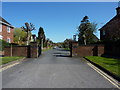
Park Avenue, Dronfield
Private road, no turning and no parking.
Image: © Peter Barr
Taken: 8 Apr 2011
0.19 miles