IMAGES TAKEN NEAR TO
Town End, DRONFIELD, S18 4BG
Introduction
This page details the photographs taken nearby to Town End, S18 4BG by members of the Geograph project.
The Geograph project started in 2005 with the aim of publishing, organising and preserving representative images for every square kilometre of Great Britain, Ireland and the Isle of Man.

There are currently over 7.5m images from over14,400 individuals and you can help contribute to the project by visiting https://www.geograph.org.uk
Image Map
Images are licensed for reuse under creativecommons.org/licenses/by-sa/2.0
Notes
- Clicking on the map will re-center to the selected point.
- The higher the marker number, the further away the image location is from the centre of the postcode.
Image Listing (15 Images Found)
Images are licensed for reuse under creativecommons.org/licenses/by-sa/2.0
Image
Details
Distance
1
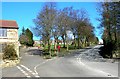
Apperknowle in NE Derbyshire
This view is taken from half way up New Road.
Image: © Andrew Loughran
Taken: 1 Mar 2006
0.01 miles
2

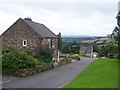
Town End, Apperknowle in NE Derbyshire.
Image: © Andrew Loughran
Taken: 1 Mar 2006
0.06 miles
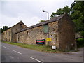
4

"The Barrack" across the village green in Apperknowle
Image: © Neil Theasby
Taken: 1 Apr 2012
0.12 miles
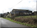
5
Barn Farm
Overlooking Barn Farm from Summerley Lower Road.
Image: © John Poyser
Taken: 20 May 2007
0.18 miles
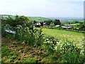
7
Line of tramroad
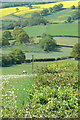
The hedge in the foreground, the line of trees in the middle distance and the groove through the field beyond all mark the line of the tramroad which used to connect Apperknowle Colliery (behind the photographer) to the railway line in the valley at Unstone. The colliery operated briefly in the 1890s.
Image: © Alan Murray-Rust
Taken: 18 May 2010
0.21 miles
9
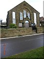
Apperknowle Methodist Church, NE Derbyshire
Image: © Andrew Loughran
Taken: 14 Feb 2006
0.21 miles
10

New Road, Apperknowle in NE Derbyshire
This view is looking north from the top of Unstone Hill (New Road)
Image: © Andrew Loughran
Taken: 14 Feb 2006
0.21 miles