IMAGES TAKEN NEAR TO
Chesterfield Road, DRONFIELD, S18 4AP
Introduction
This page details the photographs taken nearby to Chesterfield Road, S18 4AP by members of the Geograph project.
The Geograph project started in 2005 with the aim of publishing, organising and preserving representative images for every square kilometre of Great Britain, Ireland and the Isle of Man.

There are currently over 7.5m images from over14,400 individuals and you can help contribute to the project by visiting https://www.geograph.org.uk
Image Map
Images are licensed for reuse under creativecommons.org/licenses/by-sa/2.0
Notes
- Clicking on the map will re-center to the selected point.
- The higher the marker number, the further away the image location is from the centre of the postcode.
Image Listing (32 Images Found)
Images are licensed for reuse under creativecommons.org/licenses/by-sa/2.0
Image
Details
Distance
1
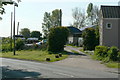
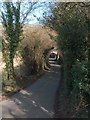
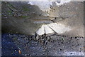
Unstone Farm
The farm drive also carries a public footpath.
Image: © Alan Murray-Rust
Taken: 18 May 2010
0.02 miles
2
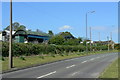
Unstone Farm
Alongside the former main road from Chesterfield to Sheffield.
Image: © Alan Murray-Rust
Taken: 18 May 2010
0.03 miles
3
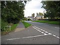
Dronfield - Halfacre Lane Junction with Chesterfield Road (B6057)
Image: © Alan Heardman
Taken: 11 Sep 2008
0.04 miles
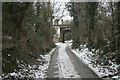
4
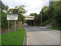
Unstone - Railway Bridge (Off Unstone Hill TJCI -18)
Image: © Alan Heardman
Taken: 11 Sep 2008
0.07 miles
7
Half Acre Lane
Looking up from the bridge over the River Drone to the railway bridge carrying the main line to Sheffield.
Image: © Alan Murray-Rust
Taken: 23 Feb 2010
0.09 miles
9
Benchmark on railway bridge on Unstone Hill
Ordnance Survey cut mark benchmark levelled at 105.689m above Newlyn Datum
Image: © Roger Templeman
Taken: 11 Feb 2019
0.12 miles
10
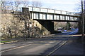
Railway Bridge over Unstone Hill
There is an OS benchmark Image on the bridge wall under the bridge identification sign
Image: © Roger Templeman
Taken: 11 Feb 2019
0.12 miles