IMAGES TAKEN NEAR TO
Halfacre Lane, DRONFIELD, S18 4AE
Introduction
This page details the photographs taken nearby to Halfacre Lane, S18 4AE by members of the Geograph project.
The Geograph project started in 2005 with the aim of publishing, organising and preserving representative images for every square kilometre of Great Britain, Ireland and the Isle of Man.

There are currently over 7.5m images from over14,400 individuals and you can help contribute to the project by visiting https://www.geograph.org.uk
Image Map
Images are licensed for reuse under creativecommons.org/licenses/by-sa/2.0
Notes
- Clicking on the map will re-center to the selected point.
- The higher the marker number, the further away the image location is from the centre of the postcode.
Image Listing (21 Images Found)
Images are licensed for reuse under creativecommons.org/licenses/by-sa/2.0
Image
Details
Distance
1
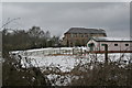
Summerley House
The area between the photographer and the house was once occupied by Summerley Colliery.
Image: © Alan Murray-Rust
Taken: 23 Feb 2010
0.01 miles
2
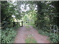
Gateway to open country.
Dronfield 2000 rotary walk.
Image: © steven ruffles
Taken: 12 Sep 2021
0.06 miles
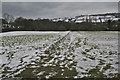
3
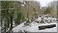
On the Drone Valley Way
We weren't tempted to "rest a while" on this day. Not sure why it says "stile" in the background, maybe it was an advance warning?
Image: © Chris Morgan
Taken: 23 Jan 2013
0.07 miles
4
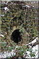
Beehive coke oven, Summerley
The entrance arch to one of the better preserved ovens in the range. See Image for a full description of the ovens.
Image: © Alan Murray-Rust
Taken: 23 Feb 2010
0.07 miles
5
Summerley beehive coke ovens
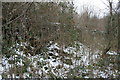
Not the easiest subject to photograph because of the invasion of vegetation, but the snow on the ground allows something to be seen.
The lower area is the platform in front of the ovens, now partly covered in rubble where the brickwork of the ovens has collapsed. The thin diagonal white line running across the picture about three quarters of the way up is the top of the bank of ovens.
There were two banks of 24 ovens, back to back, most of which appear to remain, making this probably the most extensive remaining set in the UK. The site is a Scheduled Ancient Monument, and although the citation suggests that they 'survive well', the continued degradation due to vegetation growth, including quite large trees means that this may not be the case for long.
The ovens were built between 1871 and 1876 and remained in use until 1921. Their primary market was the specialist steel making industry in Sheffield.
A close up view of the entrance arch to one of the ovens can be seen here http://www.geograph.org.uk/photo/1735333 .
Image: © Alan Murray-Rust
Taken: 23 Feb 2010
0.07 miles
6
Dronfield - Footpath between Halfacre Lane and Callywhite Lane
Image: © Alan Heardman
Taken: 11 Sep 2008
0.08 miles
7
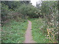
The Unstone Line
Boardwalk footpath along the line of the former Unstone branch of the Midland Railway, built to serve a number of small collieries.
Image: © Alan Murray-Rust
Taken: 23 Feb 2010
0.09 miles
8
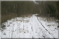
Footpath at Summerley
At this point the footpath leaves the end of Half Acre Lane and makes its way across the fields to the hamlet of Summerley.
Image: © Alan Murray-Rust
Taken: 23 Feb 2010
0.10 miles
9
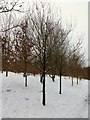
Recently planted woodland
On a footpath between Dronfield and Unstone
Image: © Graham Hogg
Taken: 23 Jan 2013
0.10 miles
10
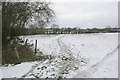
Track above Summerley House
The straight alignment and the apparent existence of a causeway suggests that this may have been a tramway associated with Summerley Colliery, which was in operation between about 1870 and 1884.
Image: © Alan Murray-Rust
Taken: 23 Feb 2010
0.13 miles