IMAGES TAKEN NEAR TO
Stone Road, DRONFIELD, S18 3AH
Introduction
This page details the photographs taken nearby to Stone Road, S18 3AH by members of the Geograph project.
The Geograph project started in 2005 with the aim of publishing, organising and preserving representative images for every square kilometre of Great Britain, Ireland and the Isle of Man.

There are currently over 7.5m images from over14,400 individuals and you can help contribute to the project by visiting https://www.geograph.org.uk
Image Map
Images are licensed for reuse under creativecommons.org/licenses/by-sa/2.0
Notes
- Clicking on the map will re-center to the selected point.
- The higher the marker number, the further away the image location is from the centre of the postcode.
Image Listing (32 Images Found)
Images are licensed for reuse under creativecommons.org/licenses/by-sa/2.0
Image
Details
Distance
1

Coal Aston Methodist Church
Primitive Methodist, 1866.
Image: © Peter Barr
Taken: 8 Apr 2011
0.02 miles
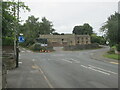
2
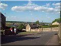
Kiln Hill in Coal Aston
A perfect evening for a stroll. This is a view from Kiln Hill as it approaches the junction with Stone Lane.
Image: © Jonathan Clitheroe
Taken: 29 May 2012
0.03 miles
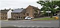
3
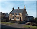
Houses on Kiln Hill, Coal Aston
Maps often wrongly assume that this is just an extension of Cross Lane but the street signs say clearly - Kiln Hill.
Image: © Neil Theasby
Taken: 6 Mar 2012
0.04 miles
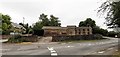
7
Roundabout in Coal Aston.
Starting point for our Dronfield 2000 rotary walk.
Image: © steven ruffles
Taken: 12 Sep 2021
0.09 miles
8
Old houses on Green Lane, Coal Aston
Looking towards Brown Lane
Image: © Chris Morgan
Taken: 8 Jun 2020
0.09 miles
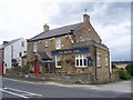
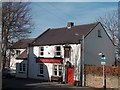
10
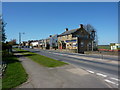
The Royal Oak and neighbouring houses
Eckington Road, Coal Aston; south of Sheffield.
Image: © Peter Barr
Taken: 8 Apr 2011
0.11 miles