IMAGES TAKEN NEAR TO
Green Lane, DRONFIELD, S18 2FG
Introduction
This page details the photographs taken nearby to Green Lane, S18 2FG by members of the Geograph project.
The Geograph project started in 2005 with the aim of publishing, organising and preserving representative images for every square kilometre of Great Britain, Ireland and the Isle of Man.

There are currently over 7.5m images from over14,400 individuals and you can help contribute to the project by visiting https://www.geograph.org.uk
Image Map (Loading...)


Getting Data...Please wait
Leaflet Map data © OpenStreetMap
Images are licensed for reuse under creativecommons.org/licenses/by-sa/2.0
Notes
- Clicking on the map will re-center to the selected point.
- The higher the marker number, the further away the image location is from the centre of the postcode.
Image Listing (22 Images Found)
Images are licensed for reuse under creativecommons.org/licenses/by-sa/2.0
Image
Details
Distance
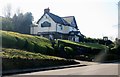
2
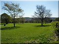
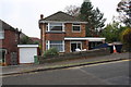
Park off Green Lane
On the road from Coal Aston to Dronfield.
Image: © Peter Barr
Taken: 8 Apr 2011
0.05 miles
3
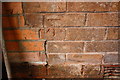
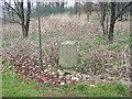
Benchmark now inside garage extension of #2 Holmesdale Road
Ordnance Survey cut mark benchmark levelled at 171.929m above Newlyn Datum
Image: © Roger Templeman
Taken: 6 Nov 2018
0.06 miles
4
#2 Holmesdale Road
There is an OS benchmark Image on the right hand side of the house (now within the garage extension) near the front corner.
Image: © Roger Templeman
Taken: 6 Nov 2018
0.07 miles
6
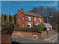
House on corner of Summerfield Road and Green Lane, Dronfield
Image: © Neil Theasby
Taken: 6 Mar 2012
0.10 miles
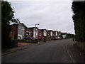
7
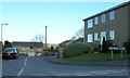
Westbank Close, Coal Aston, Sheffield.
Image: © Andrew Loughran
Taken: 1 Mar 2006
0.13 miles
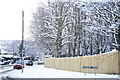
8
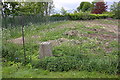
Ordnance Survey Coal Aston triangulation pillar
Half buried trig point in area of fenced off waste ground. See http://trigpointing.uk/trig/2300 for further details
Image: © Roger Templeman
Taken: 6 May 2019
0.16 miles
9
Trig point of Coal Aston
The trig point at Coal Aston is unusual in being half buried! Clearly, when installed by the OS it must have been set at ground level but subsequent work has seen earth piled around the pillar. The trig stands at the edge on an enclosure and as can be seen the ground extends for some distance still within that enclosure. Information from elsewhere is that the land is part of the garden or at least the property of an adjacent bungalow.
Image: © Trevor Littlewood
Taken: 3 Feb 2006
0.16 miles