IMAGES TAKEN NEAR TO
The Knoll, DRONFIELD, S18 2EH
Introduction
This page details the photographs taken nearby to The Knoll, S18 2EH by members of the Geograph project.
The Geograph project started in 2005 with the aim of publishing, organising and preserving representative images for every square kilometre of Great Britain, Ireland and the Isle of Man.

There are currently over 7.5m images from over14,400 individuals and you can help contribute to the project by visiting https://www.geograph.org.uk
Image Map (Loading...)


Getting Data...Please wait
Leaflet Map data © OpenStreetMap
Images are licensed for reuse under creativecommons.org/licenses/by-sa/2.0
Notes
- Clicking on the map will re-center to the selected point.
- The higher the marker number, the further away the image location is from the centre of the postcode.
Image Listing (10 Images Found)
Images are licensed for reuse under creativecommons.org/licenses/by-sa/2.0
Image
Details
Distance
1
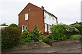
#8 Oakdell and #1 The Knoll
There is an OS benchmark Image on the right hand corner of the nearer house
Image: © Roger Templeman
Taken: 17 Jun 2019
0.05 miles
2
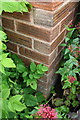
Benchmark on #8 Oakdell
Ordnance Survey cut mark benchmark levelled at 154.223m above Newlyn Datum
Image: © Roger Templeman
Taken: 17 Jun 2019
0.06 miles
3
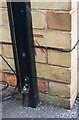
Benchmark on No. 196 Stonelow Road
The Ordnance Survey cut mark benchmark levelled at 145.634m above Newlyn Datum was verified in 1961
Image: © Luke Shaw
Taken: 17 Jun 2019
0.10 miles
4
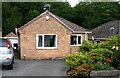
No. 196 Stonelow Road
There is an Ordnance Survey benchmark Image on the left hand side of the bungalow at its front corner where a metal gate is attached
Image: © Luke Shaw
Taken: 17 Jun 2019
0.10 miles
5
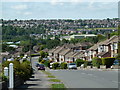
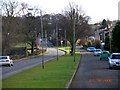
Stonelow Road and view of Dronfield
Looking down the hill along the residential street. The viewpoint is just outside the square above the junction with Oakdell on the right.
Image: © Andrew Hill
Taken: 14 Jun 2011
0.12 miles
6
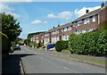
Looking along Ferndale Close
A residential street in northeastern suburbs of Dronfield off Ferndale Road.
Image: © Andrew Hill
Taken: 14 Jun 2011
0.12 miles
7
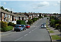
Looking up Stonelow Road
The residential street marks the edge of Dronfield with Frith Wood off to the right.
Image: © Andrew Hill
Taken: 14 Jun 2011
0.16 miles
8
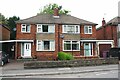
Nos. 183 and 185 Stonelow Road
Ordnance Survey documents indicate that in 1961 a benchmark levelled at 136.240m above Newlyn Datum was verified on the east angle (where an attached garage has been added) of the right hand house
Image: © Luke Shaw
Taken: 17 Jun 2019
0.16 miles
9
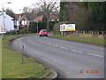
Coal Aston near Sheffield
This view is looking east along Eckington Road in the direction of Chesterfield.
Image: © Andrew Loughran
Taken: 14 Feb 2006
0.17 miles
10
Coal Aston near Sheffield
This view is looking in a westerly direction along Eckington Road.
Image: © Andrew Loughran
Taken: 16 Feb 2006
0.23 miles