IMAGES TAKEN NEAR TO
Frithwood Drive, DRONFIELD, S18 2DA
Introduction
This page details the photographs taken nearby to Frithwood Drive, S18 2DA by members of the Geograph project.
The Geograph project started in 2005 with the aim of publishing, organising and preserving representative images for every square kilometre of Great Britain, Ireland and the Isle of Man.

There are currently over 7.5m images from over14,400 individuals and you can help contribute to the project by visiting https://www.geograph.org.uk
Image Map
Images are licensed for reuse under creativecommons.org/licenses/by-sa/2.0
Notes
- Clicking on the map will re-center to the selected point.
- The higher the marker number, the further away the image location is from the centre of the postcode.
Image Listing (24 Images Found)
Images are licensed for reuse under creativecommons.org/licenses/by-sa/2.0
Image
Details
Distance
1
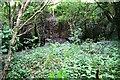
Culvert and gate to former sports ground from Firth Wood
Ordnance Survey records indicate that in 1961 a benchmark levelled at 122.045m above Newlyn Datum was verified on the bottom step of a path leading to a sports ground on the far side of the gate
Image: © Luke Shaw
Taken: 17 Jun 2019
0.04 miles
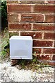
2
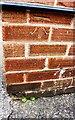
Benchmark on No. 17 Shireoaks Road
Ordnance Survey cut mark benchmark levelled at 129.388m above Newlyn Datum verified in 1961
Image: © Luke Shaw
Taken: 17 Jun 2019
0.05 miles
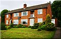
3
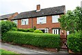
Nos. 15 and 17 Shireoaks Road
There is an Ordnance Survey benchmark Image on the side of the right hand house at its front corner
Image: © Luke Shaw
Taken: 17 Jun 2019
0.06 miles
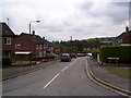
4
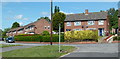
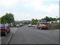
Houses on Shireoaks Road, Dronfield
A residential street off Stonelow Road with footpath access from this corner to Frith Wood.
Image: © Andrew Hill
Taken: 14 Jun 2011
0.06 miles
5
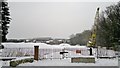
The map says there's a big factory here - not any more!
But maybe when the snow's gone a new one may appear?
Image: © Chris Morgan
Taken: 23 Jan 2013
0.07 miles
7
Nos. 133, 135, 137 & 139 Stonelow Road
There is an Ordnance Survey benchmark Image on the right hand side of the right hand house at its front corner
Image: © Luke Shaw
Taken: 17 Jun 2019
0.12 miles
8
Benchmark on No. 137 Stonelow Road
Ordnance Survey cut mark benchmark levelled at 136.941m above Newlyn Datum verified in 1961
Image: © Luke Shaw
Taken: 17 Jun 2019
0.13 miles
9
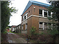
Industrial Unit with potential
A derelict industrial building virtually next to the beauty spot of Frith Wood
Image: © Roger Temple
Taken: 22 Oct 2006
0.13 miles
10
Dronfield - Looking back down Callywhite Lane
Image: © Alan Heardman
Taken: 22 May 2008
0.14 miles