IMAGES TAKEN NEAR TO
Highfields Road, DRONFIELD, S18 1UU
Introduction
This page details the photographs taken nearby to Highfields Road, S18 1UU by members of the Geograph project.
The Geograph project started in 2005 with the aim of publishing, organising and preserving representative images for every square kilometre of Great Britain, Ireland and the Isle of Man.

There are currently over 7.5m images from over14,400 individuals and you can help contribute to the project by visiting https://www.geograph.org.uk
Image Map
Images are licensed for reuse under creativecommons.org/licenses/by-sa/2.0
Notes
- Clicking on the map will re-center to the selected point.
- The higher the marker number, the further away the image location is from the centre of the postcode.
Image Listing (25 Images Found)
Images are licensed for reuse under creativecommons.org/licenses/by-sa/2.0
Image
Details
Distance
1
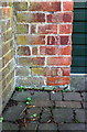
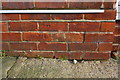
Benchmark on garage of #20 Highfields Road
Ordnance Survey cut mark benchmark levelled at 191.870m above Newlyn Datum
Image: © Roger Templeman
Taken: 11 Feb 2019
0.02 miles
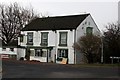
2
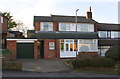
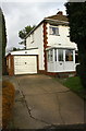
#20 Highfields Road
There is an OS benchmark Image in the bricks on the left hand side of the garage door
Image: © Roger Templeman
Taken: 11 Feb 2019
0.02 miles
3
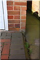
Benchmark on #55 Hollins Spring Avenue
Ordnance Survey cut mark benchmark levelled at 176.280m above Newlyn Datum
Image: © Roger Templeman
Taken: 11 Feb 2019
0.08 miles
4
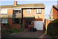
#55 Hollins Spring Avenue
There in an OS benchmark Image on bricks on the front of the house, right of the garage door.
Image: © Roger Templeman
Taken: 11 Feb 2019
0.09 miles
5
Benchmark on #23 Hilltop Road
Ordnance Survey cut mark benchmark levelled at 192.980m above Newlyn Datum
Image: © Roger Templeman
Taken: 11 Feb 2019
0.10 miles
6
#23 Hilltop Road with attached garage
There is an OS benchmark Image on the left hand side of the house near the front corner.
Image: © Roger Templeman
Taken: 11 Feb 2019
0.10 miles
7
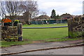
Entrance to recreation ground from Gosforth Lane
There is an OS benchmark Image on the right hand gatepost
Image: © Roger Templeman
Taken: 11 Feb 2019
0.11 miles
8
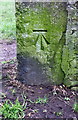
Benchmark on gatepost at entrance to recreation ground from Gosforth Lane
Ordnance Survey cut mark benchmark levelled at 197.700m above Newlyn Datum
Image: © Roger Templeman
Taken: 11 Feb 2019
0.13 miles
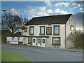
10
The Hyde Park Inn
Popular pub in Hill Top
Image: © Graham Hogg
Taken: 18 Nov 2013
0.15 miles