IMAGES TAKEN NEAR TO
Constable Close, DRONFIELD, S18 1TE
Introduction
This page details the photographs taken nearby to Constable Close, S18 1TE by members of the Geograph project.
The Geograph project started in 2005 with the aim of publishing, organising and preserving representative images for every square kilometre of Great Britain, Ireland and the Isle of Man.

There are currently over 7.5m images from over14,400 individuals and you can help contribute to the project by visiting https://www.geograph.org.uk
Image Map
Images are licensed for reuse under creativecommons.org/licenses/by-sa/2.0
Notes
- Clicking on the map will re-center to the selected point.
- The higher the marker number, the further away the image location is from the centre of the postcode.
Image Listing (11 Images Found)
Images are licensed for reuse under creativecommons.org/licenses/by-sa/2.0
Image
Details
Distance
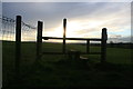
3
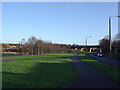
Footpath along southern boundary of Gosforth Estate
The first sunshine the walkers had seen all day.
Image: © Chris Morgan
Taken: 18 Nov 2013
0.13 miles
4

Footpath at the edge of Dronfield
The footpath is squeezed between the fence and the bushes
Image: © Graham Hogg
Taken: 18 Nov 2013
0.16 miles
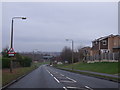
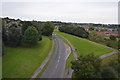
5
Gosforth Valley Flyover
Now become an iconic symbol for this part of the town.
Image: © Ted Thomas
Taken: 14 Jan 2007
0.18 miles
7
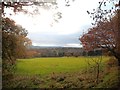
Pasture near Cowley Bottom
An autumnal scene pictured from a farm track near Cowley Lane.
Image: © Jonathan Clitheroe
Taken: 7 Nov 2012
0.21 miles
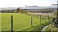
8
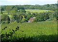
Hillside meadow by Cowly Lane
A sloping meadow viewed from the lane.
Image: © Andrew Hill
Taken: 24 May 2011
0.24 miles
9
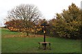
Four way signpost
Where footpaths cross at the southern edge of Dronfield
Image: © Graham Hogg
Taken: 18 Nov 2013
0.25 miles