IMAGES TAKEN NEAR TO
Wreakes Lane, DRONFIELD, S18 1NW
Introduction
This page details the photographs taken nearby to Wreakes Lane, S18 1NW by members of the Geograph project.
The Geograph project started in 2005 with the aim of publishing, organising and preserving representative images for every square kilometre of Great Britain, Ireland and the Isle of Man.

There are currently over 7.5m images from over14,400 individuals and you can help contribute to the project by visiting https://www.geograph.org.uk
Image Map
Images are licensed for reuse under creativecommons.org/licenses/by-sa/2.0
Notes
- Clicking on the map will re-center to the selected point.
- The higher the marker number, the further away the image location is from the centre of the postcode.
Image Listing (44 Images Found)
Images are licensed for reuse under creativecommons.org/licenses/by-sa/2.0
Image
Details
Distance
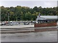
2
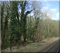
Woodland beside the Derby to Sheffield railway
Image: © JThomas
Taken: 18 Apr 2013
0.07 miles
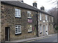
7
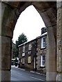
'Frame It', framed
A picture gallery and framing shop here framed by an arch of the Peel Monument
Image: © Graham Hogg
Taken: 23 Jan 2013
0.11 miles