IMAGES TAKEN NEAR TO
Rosamond Avenue, SHEFFIELD, S17 4LT
Introduction
This page details the photographs taken nearby to Rosamond Avenue, S17 4LT by members of the Geograph project.
The Geograph project started in 2005 with the aim of publishing, organising and preserving representative images for every square kilometre of Great Britain, Ireland and the Isle of Man.

There are currently over 7.5m images from over14,400 individuals and you can help contribute to the project by visiting https://www.geograph.org.uk
Image Map
Images are licensed for reuse under creativecommons.org/licenses/by-sa/2.0
Notes
- Clicking on the map will re-center to the selected point.
- The higher the marker number, the further away the image location is from the centre of the postcode.
Image Listing (60 Images Found)
Images are licensed for reuse under creativecommons.org/licenses/by-sa/2.0
Image
Details
Distance
1
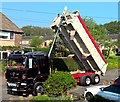
Colas Microsurfacing team at work
The truck carries a cargo of water and aggregate that can be spread at about 2-3 mph on a straight and level road covering cracks and pot holes leaving a surface that should be good for up to 8-10 years.
Image: © Chris Morgan
Taken: 10 Jul 2018
0.03 miles
2
Delivered to the drive
A load of tarmac has arrived by very smart Foden truck.
Image: © Chris Morgan
Taken: 8 May 2018
0.06 miles
3
Death of a tree
Supported by its neighbours this tree had slipped too far. It was felled later in the day.
Image: © Chris Morgan
Taken: 22 Jul 2019
0.08 miles
4

View from Abbeydale Park, upper cricket pitch
After the match was over, looking towards Poynton Wood and Bradway
Image: © Chris Morgan
Taken: 4 Jul 2022
0.09 miles
5
Street trees in Sheffield are under threat
But some are to be allowed to survive. These two seem to have found a grassy corner where they can avoid the chop, although a vehicle recently backed into the one on the right to give it some rough pruning.
Image: © Chris Morgan
Taken: 24 Feb 2017
0.09 miles
6
We three trees are not staying long
Sheffield City Council's 5 year scheme to resurface most roads and pavements calls for street trees to be assessed. These three cherries are growing too big for their location, their trunks now occupying more than half the width of the pavement. They're going to have to go. Replacements will be planted about 50-100 yards further along the road on a grassy corner.
In 25 years the improvement may be appreciated.
Image: © Chris Morgan
Taken: 25 Apr 2017
0.09 miles
7

Volunteers clearing fallen trees
After a foot of wet, heavy snow had fallen the previous day - and had mostly all melted by the day following.
Image: © Chris Morgan
Taken: 12 Mar 2023
0.12 miles
8

Bluebells in Poynton Wood
The whole hillside below the canopy of trees carpeted in blue.
Image: © Chris Morgan
Taken: 4 May 2022
0.13 miles
9

Bluebell time in Poynton Wood
A blue carpet at present
Image: © Chris Morgan
Taken: 4 May 2022
0.13 miles
10
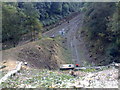
Dore South Junction, Sheffield
Below Poynton Wood and Bradway Bank to the right, and Twentywell Lane to the left. In days gone by there was a signal box about here. This was taken from above a small tunnel covering the tightly curving single track linking to the Hope Valley line towards Manchester. It was previously a double track. Freight trains use this line to and from the Lafarge Cement works at Hope.
The double track is the mainline used by East Midlands Trains between Sheffield and London St Pancras. It is also used by Crosscountry Trains running from as far south as Penzance and Reading up to Edinburgh and Glasgow. Northern Trains pass here between Nottingham and Leeds. East Midlands Trains also operate from Liverpool to Norwich. A trainspotters heaven in days gone by.
At the time this picture was taken contractors were ruthlessly removing almost all vegetation from the hillsides due to fears of trees falling on the line! It revealed much that had been hidden for generations - this was only the start.
Image: © Chris Morgan
Taken: 14 Oct 2008
0.13 miles