IMAGES TAKEN NEAR TO
Queen Victoria Road, SHEFFIELD, S17 4HT
Introduction
This page details the photographs taken nearby to Queen Victoria Road, S17 4HT by members of the Geograph project.
The Geograph project started in 2005 with the aim of publishing, organising and preserving representative images for every square kilometre of Great Britain, Ireland and the Isle of Man.

There are currently over 7.5m images from over14,400 individuals and you can help contribute to the project by visiting https://www.geograph.org.uk
Image Map
Images are licensed for reuse under creativecommons.org/licenses/by-sa/2.0
Notes
- Clicking on the map will re-center to the selected point.
- The higher the marker number, the further away the image location is from the centre of the postcode.
Image Listing (33 Images Found)
Images are licensed for reuse under creativecommons.org/licenses/by-sa/2.0
Image
Details
Distance
1
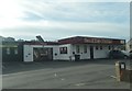
Sheffield Animal Hospital, Baslow Road
Now closed, though it still appears on website www.any-uk-vet.co.uk/sheffield-animal-hospital/index.htm
Image: © Peter Barr
Taken: 30 Jan 2010
0.10 miles

6
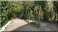
Totley Lane bridleway
A footpath and bridleway at the junction with Mickley Lane
Image: © Chris Morgan
Taken: 8 Apr 2020
0.13 miles
7
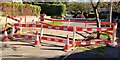
Road repairs after water main leak
Wollaton Road, Bradway, Sheffield.
No buses this way today!
Image: © Chris Morgan
Taken: 2 Oct 2019
0.13 miles
9
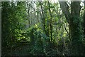
Ivy Covered Gate and Trees near Mickley Hall, Sheffield
This gate off a public footpath in a wooded area of suburban Sheffield appears to have been forgotten about. Nearby is 'The Lumb' (watercourse), possibly related to the word 'limit' and referring to the historic boundary of the Kingdom of Northumbria.
Image: © Andrew Tryon
Taken: 29 Dec 2015
0.14 miles