IMAGES TAKEN NEAR TO
Totley Grange Close, SHEFFIELD, S17 4AG
Introduction
This page details the photographs taken nearby to Totley Grange Close, S17 4AG by members of the Geograph project.
The Geograph project started in 2005 with the aim of publishing, organising and preserving representative images for every square kilometre of Great Britain, Ireland and the Isle of Man.

There are currently over 7.5m images from over14,400 individuals and you can help contribute to the project by visiting https://www.geograph.org.uk
Image Map (Loading...)


Getting Data...Please wait
Leaflet Map data © OpenStreetMap
Images are licensed for reuse under creativecommons.org/licenses/by-sa/2.0
Notes
- Clicking on the map will re-center to the selected point.
- The higher the marker number, the further away the image location is from the centre of the postcode.
Image Listing (42 Images Found)
Images are licensed for reuse under creativecommons.org/licenses/by-sa/2.0
Image
Details
Distance
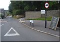
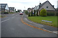
1
Totley Grange Drive from the main road
Modern houses in Totley set back from the A621 Baslow Road.
Image: © Andrew Hill
Taken: 24 Jul 2011
0.07 miles
2
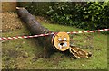
The Totley Walrus has been captured!
A recently felled tree beside the A621 Baslow Road has been stripped of its branches, but much of the trunk remains, decorated with safety tape and a bit of enterprising private art. I wonder how long this will be left to amuse passers by? Update: by 9.30 this morning (4th July) the Walrus had been cut up and was being removed.
Image: © Chris Morgan
Taken: 28 Jun 2014
0.08 miles
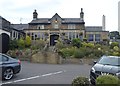
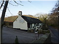
4

Ye Olde Cross Scythes, Totley
An old coaching inn
Image: © Chris Morgan
Taken: 8 Apr 2020
0.09 miles
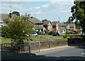
5
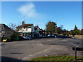
Liberty Foods Farm Shop
Junction of Main Avenue and Baslow Road, Totley, Sheffield
Image: © Peter Barr
Taken: 30 Jan 2010
0.09 miles
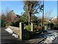
7
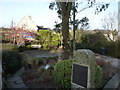
The Pinfold Garden, Hillfoot Road, Totley
"The original use of this area as listed in the 1847 awards was for impounding stray cattle and horses and held by the pinder until a fee was paid,namely " a pinfold". Totley and District Environment Society created and funded this project in the late 1970's, assistance with labour was by students of Totley Polytechnic College. The water troughs were raised from their original position 8 feet below the present ground level. These had been fed from a spring. They were buried beneath tipped rubbish for almost forty years. Ownership is by the residents of Totley." From a descriptive plaque in the garden
Image: © Peter Barr
Taken: 1 Feb 2010
0.10 miles
8
Pinfold Garden, Totley
Once this garden site was the village's pinfold - for the penning of stray farm animals.
Image: © Neil Theasby
Taken: 10 Feb 2015
0.10 miles