IMAGES TAKEN NEAR TO
Myrce Way, SHEFFIELD, S17 3SF
Introduction
This page details the photographs taken nearby to Myrce Way, S17 3SF by members of the Geograph project.
The Geograph project started in 2005 with the aim of publishing, organising and preserving representative images for every square kilometre of Great Britain, Ireland and the Isle of Man.

There are currently over 7.5m images from over14,400 individuals and you can help contribute to the project by visiting https://www.geograph.org.uk
Image Map
Images are licensed for reuse under creativecommons.org/licenses/by-sa/2.0
Notes
- Clicking on the map will re-center to the selected point.
- The higher the marker number, the further away the image location is from the centre of the postcode.
Image Listing (40 Images Found)
Images are licensed for reuse under creativecommons.org/licenses/by-sa/2.0
Image
Details
Distance
1
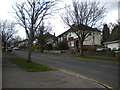
Saxon Avenue, Dore
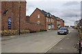
Here, off Furniss Avenue, Bellway Homes is building new houses which, according to the company 'cover a range of styles including townhouses and executive detached properties, sure to appeal to professionals and families alike'. The location is certainly a good one, close to Dore village, and perhaps for once justifies the overworked phrase 'sought after area'. The house on the immediate left is a show home and the builder's name for the development is 'Wyvern Grange', evoking Dore's ancient connection with the wyvern symbol.
Image: © Stephen McKay
Taken: 14 Mar 2018
0.05 miles
3
Old Site of King Ecgbert School, Dore, Sheffield
Now subject to a proposed housing development.
Image: © John Mace
Taken: 1 Aug 2008
0.08 miles
4
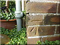
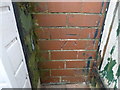
Cut Mark 60 Furniss Ave Sheffield
as above
Image: © Monica Stagg
Taken: 1 Mar 2015
0.10 miles
5
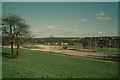
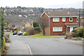
Furniss Avenue, Totley Brook
A view from the end of Totley Brook Road, as Furniss Avenue climbs towards Church Lane at the south end of Dore.
Image: © Richard Vince
Taken: 27 Apr 2013
0.12 miles
6
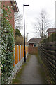
Path to Bushey Wood Road
This narrow path squeezes between houses to give pedestrian access from Durvale Court to Bushey Wood Road via Wyvern Gardens.
Image: © Stephen McKay
Taken: 14 Mar 2018
0.14 miles
8
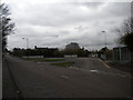
Bus turning circle, Totley Brook (1)
The large turning circle on Totley Brook Road, configured to allow buses to arrive from and depart in either direction, contains three bus stops: the one on the right is the nominal terminus of First Sheffield route 98 to Ecclesfield via Sheffield city centre, while the other two are used by school services to King Ecgbert School (out of frame to the right).
Image: © Richard Vince
Taken: 27 Apr 2013
0.19 miles
9
Wyvern Gardens, Dore
Wyvern Gardens is a cul-de-sac leading off Bushey Wood Road with views across the Sheaf valley. The houses here are much newer than those on Bushey Wood Road or Furniss Avenue to the south, so this is evidently an infill development. The Wyvern name has a strong association with Dore going back to the 9th century when the area was at the boundary between the kingdoms of Mercia and Northumbria. In 829 Mercia had recently been conquered by the King of Wessex and it was here at Dore that the Northumbrians accepted the primacy of Wessex and King Ecgbert as overlord of all England. The wyvern was the war emblem of Wessex.
Image: © Stephen McKay
Taken: 14 Mar 2018
0.19 miles
10
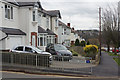
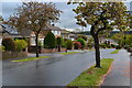
Furniss Avenue, Totley Brook
This is near the bottom of Furniss Avenue with Durvale Court, a cul-de-sac, leading off to the left.
Image: © Stephen McKay
Taken: 14 Mar 2018
0.19 miles