IMAGES TAKEN NEAR TO
Furniss Avenue, SHEFFIELD, S17 3QL
Introduction
This page details the photographs taken nearby to Furniss Avenue, S17 3QL by members of the Geograph project.
The Geograph project started in 2005 with the aim of publishing, organising and preserving representative images for every square kilometre of Great Britain, Ireland and the Isle of Man.

There are currently over 7.5m images from over14,400 individuals and you can help contribute to the project by visiting https://www.geograph.org.uk
Image Map
Images are licensed for reuse under creativecommons.org/licenses/by-sa/2.0
Notes
- Clicking on the map will re-center to the selected point.
- The higher the marker number, the further away the image location is from the centre of the postcode.
Image Listing (18 Images Found)
Images are licensed for reuse under creativecommons.org/licenses/by-sa/2.0
Image
Details
Distance
1
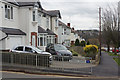
Furniss Avenue, Totley Brook
This is near the bottom of Furniss Avenue with Durvale Court, a cul-de-sac, leading off to the left.
Image: © Stephen McKay
Taken: 14 Mar 2018
0.01 miles
2
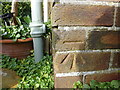
Cut Mark 60 Furniss Ave Sheffield
as above
Image: © Monica Stagg
Taken: 1 Mar 2015
0.10 miles
3
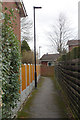
Path to Bushey Wood Road
This narrow path squeezes between houses to give pedestrian access from Durvale Court to Bushey Wood Road via Wyvern Gardens.
Image: © Stephen McKay
Taken: 14 Mar 2018
0.13 miles
4
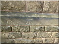
Cut Mark 22 King Ecgbert Rd Sheffield
as above
Image: © Monica Stagg
Taken: 1 Mar 2015
0.14 miles
5
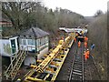
Preparing to lay new junction at Dore West Junction
Image: © Chris Morgan
Taken: 14 Jan 2023
0.17 miles
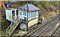
6

Track relaying by Totley Tunnel East signal box
Sadly, the old signal box will become redundant once the current work in this area is complete and will probably have to go.
Image: © Chris Morgan
Taken: 21 Jan 2023
0.18 miles
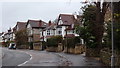
7
Wyvern Gardens, Dore
Wyvern Gardens is a cul-de-sac leading off Bushey Wood Road with views across the Sheaf valley. The houses here are much newer than those on Bushey Wood Road or Furniss Avenue to the south, so this is evidently an infill development. The Wyvern name has a strong association with Dore going back to the 9th century when the area was at the boundary between the kingdoms of Mercia and Northumbria. In 829 Mercia had recently been conquered by the King of Wessex and it was here at Dore that the Northumbrians accepted the primacy of Wessex and King Ecgbert as overlord of all England. The wyvern was the war emblem of Wessex.
Image: © Stephen McKay
Taken: 14 Mar 2018
0.18 miles
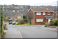
9
King Ecgbert Road
The residential street leads up towards King Ecgbert secondary school.
Image: © Andrew Hill
Taken: 20 Nov 2012
0.19 miles
10
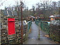
Railway footbridge and post box
View from Totley Brook Road. There are some houses and bungalows in the valley floor, with houses on Marstone Crescent above the steep wooded bank.
Image: © Andrew Hill
Taken: 20 Nov 2012
0.19 miles