IMAGES TAKEN NEAR TO
Burlington Glen, SHEFFIELD, S17 3PL
Introduction
This page details the photographs taken nearby to Burlington Glen, S17 3PL by members of the Geograph project.
The Geograph project started in 2005 with the aim of publishing, organising and preserving representative images for every square kilometre of Great Britain, Ireland and the Isle of Man.

There are currently over 7.5m images from over14,400 individuals and you can help contribute to the project by visiting https://www.geograph.org.uk
Image Map
Images are licensed for reuse under creativecommons.org/licenses/by-sa/2.0
Notes
- Clicking on the map will re-center to the selected point.
- The higher the marker number, the further away the image location is from the centre of the postcode.
Image Listing (23 Images Found)
Images are licensed for reuse under creativecommons.org/licenses/by-sa/2.0
Image
Details
Distance
1
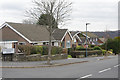
Devonshire Road, Dore
Trim and tidy suburbia: Devonshire Road drops into the Sheaf valley from its junction with Gilleyfield Avenue.
Image: © Stephen McKay
Taken: 14 Mar 2018
0.05 miles
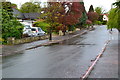
3
Gilleyfield Avenue, Dore
A residential street seen from the top of a long footpath from the bottom end of Devonshire Road.
Image: © Andrew Hill
Taken: 20 Nov 2012
0.07 miles
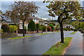
4

Christmas lights on Devonshire Road
Many houses in the area decorate their front gardens for Christmas. This is one of the bigger displays.
Image: © Graham Hogg
Taken: 14 Dec 2020
0.10 miles
6

All lit up for Christmas
One of many houses in the area which really go to town with their Christmas lights and decorations. A video would do this one more justice as the lights cycle through several colours.
Image: © Graham Hogg
Taken: 14 Dec 2020
0.14 miles
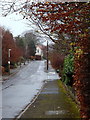
7
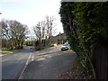
On Dore Road
At junction of Vicarage Lane
Image: © Peter Barr
Taken: 1 Feb 2010
0.16 miles
8
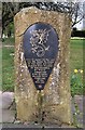
Commemorative stone, Dore village
In 829 A.D. King Ecgbert of Wessex may have been offered "submission and peace" by the Northumbrians of King Eanred, and unified England. Other records suggest Northumbria was laid waste, culprits unclear and it has also been suggested Eanred lived until at least 840 and possibly as late as 850. See; https://en.wikipedia.org/wiki/Eanred_of_Northumbria
This stone was erected in 1968.
Image: © Chris Morgan
Taken: 9 Apr 2020
0.20 miles
9
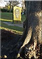
Dore Village Green and the commemoration stone
The stone recognises that at Dore in 829 A.D., King Ecgbert of Wessex suppressed the forces of King Eanred of Northumbria to become the "first overlord of all England". The stone was erected in 1968. I last photographed it on Boxing Day, 2012. See http://www.geograph.org.uk/photo/3271302
Image: © Neil Theasby
Taken: 5 Jan 2017
0.21 miles
10
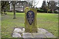
Commemorative stone - Dore village green
The stone recognises that at Dore in 829 A.D., King Ecgbert of Wessex suppressed the forces of King Eanred of Northumbria to become the "first overlord of all England". The stone was erected in 1968.
Image: © Neil Theasby
Taken: 26 Dec 2012
0.21 miles