IMAGES TAKEN NEAR TO
Rushley Drive, SHEFFIELD, S17 3EL
Introduction
This page details the photographs taken nearby to Rushley Drive, S17 3EL by members of the Geograph project.
The Geograph project started in 2005 with the aim of publishing, organising and preserving representative images for every square kilometre of Great Britain, Ireland and the Isle of Man.

There are currently over 7.5m images from over14,400 individuals and you can help contribute to the project by visiting https://www.geograph.org.uk
Image Map
Images are licensed for reuse under creativecommons.org/licenses/by-sa/2.0
Notes
- Clicking on the map will re-center to the selected point.
- The higher the marker number, the further away the image location is from the centre of the postcode.
Image Listing (39 Images Found)
Images are licensed for reuse under creativecommons.org/licenses/by-sa/2.0
Image
Details
Distance
2
Cut Mark 33 Causeway Head Rd Dore
as above
Image: © Monica Stagg
Taken: 1 Mar 2015
0.13 miles
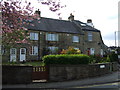

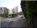
5

Causeway Head Road, Dore
Looking down the residential street just below the junction with Heather Lea Avenue.
Image: © Andrew Hill
Taken: 20 Nov 2012
0.15 miles
6
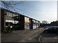
Co-operative Food store, Dore
A small supermarket on Devonshire Terrace Road in the centre of the village. Further shops on Causeway Head Road are visible on the left.
Image: © Richard Vince
Taken: 27 Apr 2013
0.16 miles
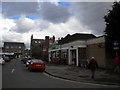
7
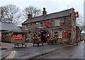
Devonshire Arms, Dore
On Dore High Street.
Image: © Andrew Hill
Taken: 20 Nov 2012
0.16 miles
8
On Dore Road
At junction of Vicarage Lane
Image: © Peter Barr
Taken: 1 Feb 2010
0.16 miles
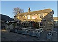
10
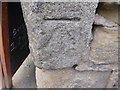
Cut Mark Devonshire Arms Public House Dore
as above
Image: © Monica Stagg
Taken: 1 Mar 2015
0.16 miles