IMAGES TAKEN NEAR TO
Lane Head Road, SHEFFIELD, S17 3BD
Introduction
This page details the photographs taken nearby to Lane Head Road, S17 3BD by members of the Geograph project.
The Geograph project started in 2005 with the aim of publishing, organising and preserving representative images for every square kilometre of Great Britain, Ireland and the Isle of Man.

There are currently over 7.5m images from over14,400 individuals and you can help contribute to the project by visiting https://www.geograph.org.uk
Image Map
Images are licensed for reuse under creativecommons.org/licenses/by-sa/2.0
Notes
- Clicking on the map will re-center to the selected point.
- The higher the marker number, the further away the image location is from the centre of the postcode.
Image Listing (66 Images Found)
Images are licensed for reuse under creativecommons.org/licenses/by-sa/2.0
Image
Details
Distance
3
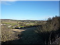
Houses at Totley Bents, Sheffield
Further on is Townhead, Dore
Image: © Peter Barr
Taken: 30 Jan 2010
0.05 miles
4
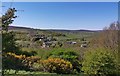
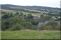
View over Totley Bents from Baslow Road
Image: © Chris Morgan
Taken: 21 Apr 2020
0.06 miles
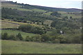
7
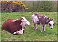
Old friends at ease
These two are inseparable, the only animals in the field.
Image: © Chris Morgan
Taken: 25 Apr 2016
0.10 miles