IMAGES TAKEN NEAR TO
Blackstock Road, SHEFFIELD, S14 1JB
Introduction
This page details the photographs taken nearby to Blackstock Road, S14 1JB by members of the Geograph project.
The Geograph project started in 2005 with the aim of publishing, organising and preserving representative images for every square kilometre of Great Britain, Ireland and the Isle of Man.

There are currently over 7.5m images from over14,400 individuals and you can help contribute to the project by visiting https://www.geograph.org.uk
Image Map
Images are licensed for reuse under creativecommons.org/licenses/by-sa/2.0
Notes
- Clicking on the map will re-center to the selected point.
- The higher the marker number, the further away the image location is from the centre of the postcode.
Image Listing (6 Images Found)
Images are licensed for reuse under creativecommons.org/licenses/by-sa/2.0
Image
Details
Distance
1
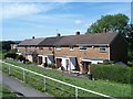
Blackstock Road
Local authority built housing on Blackstock Road.
Image: © Martin Speck
Taken: 11 Aug 2009
0.04 miles
2
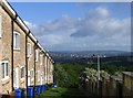
Gaunt Road, Sheffield
Steeply inclined houses on Gaunt Road with a view across to Sheffield City centre.
Image: © Graham Hardy
Taken: 29 May 2006
0.05 miles
3
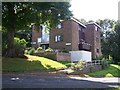
Gaunt Place
Local authority flats surrounded by lots of green space.
Image: © Martin Speck
Taken: 11 Aug 2009
0.05 miles
4
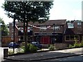
Horse & Groom, Gleadless Valley, Sheffield
Image: © Graham Hogg
Taken: 9 Aug 2010
0.10 miles
5
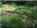
Pond near the site of Lees Hall Farm - demolished in the 1960's
Image: © Neil Theasby
Taken: 2 Aug 2010
0.13 miles
6
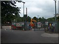
Blackstock Road Recycling Site - Sheffield City Council
Image: © Neil Theasby
Taken: 2 Aug 2010
0.21 miles