IMAGES TAKEN NEAR TO
Ironside Walk, SHEFFIELD, S14 1FA
Introduction
This page details the photographs taken nearby to Ironside Walk, S14 1FA by members of the Geograph project.
The Geograph project started in 2005 with the aim of publishing, organising and preserving representative images for every square kilometre of Great Britain, Ireland and the Isle of Man.

There are currently over 7.5m images from over14,400 individuals and you can help contribute to the project by visiting https://www.geograph.org.uk
Image Map
Images are licensed for reuse under creativecommons.org/licenses/by-sa/2.0
Notes
- Clicking on the map will re-center to the selected point.
- The higher the marker number, the further away the image location is from the centre of the postcode.
Image Listing (38 Images Found)
Images are licensed for reuse under creativecommons.org/licenses/by-sa/2.0
Image
Details
Distance

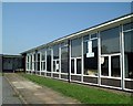
4
Hemsworth Junior School (Now Demolished)
Taken from Constable road.This was demolished in 2003
Image: © richard newall
Taken: 12 Jul 2003
0.07 miles

8
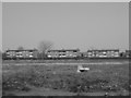
Previous Site of Hemsworth Junior School
Taken from Constable Road.This is due to be a housing development
Image: © richard newall
Taken: 24 Apr 2004
0.08 miles
10
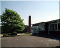
Hemsworth Junior School (Now Demolished)
This was demolished in 2003
Image: © richard newall
Taken: 1 Jul 2003
0.09 miles