IMAGES TAKEN NEAR TO
Orgreave Rise, SHEFFIELD, S13 9XZ
Introduction
This page details the photographs taken nearby to Orgreave Rise, S13 9XZ by members of the Geograph project.
The Geograph project started in 2005 with the aim of publishing, organising and preserving representative images for every square kilometre of Great Britain, Ireland and the Isle of Man.

There are currently over 7.5m images from over14,400 individuals and you can help contribute to the project by visiting https://www.geograph.org.uk
Image Map
Images are licensed for reuse under creativecommons.org/licenses/by-sa/2.0
Notes
- Clicking on the map will re-center to the selected point.
- The higher the marker number, the further away the image location is from the centre of the postcode.
Image Listing (14 Images Found)
Images are licensed for reuse under creativecommons.org/licenses/by-sa/2.0
Image
Details
Distance
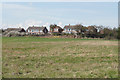
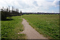
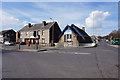
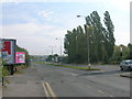
2
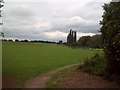
Woodhouse Mill Recreation Ground
Urban green space viewed here from the park entrance by the B6200 Road. The path is following the western bank of the River Rother.
Image: © Jonathan Clitheroe
Taken: 1 Jul 2012
0.11 miles
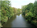
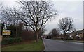
4
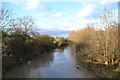
River Rother from Retford Road Bridge
At Woodhouse Mill
Image: © Neil Theasby
Taken: 7 Dec 2012
0.17 miles
6
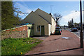
Voice of God Fellowship Church
On Furnace Lane, Woodhouse Mill. http://www.geograph.org.uk/photo/4906810
Image: © Ian S
Taken: 13 Apr 2016
0.18 miles
7
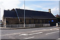
Voice of God Fellowship Church
On Furnace Lane, Woodhouse Mill. http://www.geograph.org.uk/photo/4906807
Image: © Ian S
Taken: 13 Apr 2016
0.19 miles
10
Railway bridge on Retford Road, Woodhouse Mill, Sheffield
Image: © Steve Fareham
Taken: 11 Jan 2009
0.21 miles