IMAGES TAKEN NEAR TO
Handsworth Road, SHEFFIELD, S13 9LR
Introduction
This page details the photographs taken nearby to Handsworth Road, S13 9LR by members of the Geograph project.
The Geograph project started in 2005 with the aim of publishing, organising and preserving representative images for every square kilometre of Great Britain, Ireland and the Isle of Man.

There are currently over 7.5m images from over14,400 individuals and you can help contribute to the project by visiting https://www.geograph.org.uk
Image Map
Images are licensed for reuse under creativecommons.org/licenses/by-sa/2.0
Notes
- Clicking on the map will re-center to the selected point.
- The higher the marker number, the further away the image location is from the centre of the postcode.
Image Listing (8 Images Found)
Images are licensed for reuse under creativecommons.org/licenses/by-sa/2.0
Image
Details
Distance
1
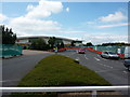
Is it a Tesco? Oops, no it's an Asda Walmart Mega Store
Image: © Peter Barr
Taken: 19 Jul 2011
0.02 miles

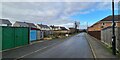
3
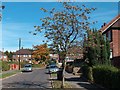
Richmond Park Crescent, Handsworth, Sheffield
Image: © Neil Theasby
Taken: 27 Sep 2011
0.12 miles
4
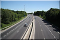
Sheffield Parkway
View east from the footbridge
Image: © Richard Croft
Taken: 17 Jun 2010
0.15 miles
5
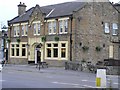
Norfolk Arms, Handsworth
One of the old pubs in the area, the Norfolk Arms is identified on the 1901 OS map. Just down the road from here, Benjamin Huntsman, inventor of crucible steel lived for a while in 1742,
Image: © David Morris
Taken: 26 Sep 2005
0.18 miles
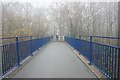
7

Parkway footbridge
Footbridge over Sheffield Parkway A57 part of the Trans-Pennine Trail and NCN route 67
Image: © Richard Croft
Taken: 17 Jun 2010
0.22 miles
8
Footbridge on the Trans Pennine Trail over the A630
Image: © Ian S
Taken: 18 Dec 2019
0.23 miles