IMAGES TAKEN NEAR TO
Medlock Crescent, SHEFFIELD, S13 9BT
Introduction
This page details the photographs taken nearby to Medlock Crescent, S13 9BT by members of the Geograph project.
The Geograph project started in 2005 with the aim of publishing, organising and preserving representative images for every square kilometre of Great Britain, Ireland and the Isle of Man.

There are currently over 7.5m images from over14,400 individuals and you can help contribute to the project by visiting https://www.geograph.org.uk
Image Map
Images are licensed for reuse under creativecommons.org/licenses/by-sa/2.0
Notes
- Clicking on the map will re-center to the selected point.
- The higher the marker number, the further away the image location is from the centre of the postcode.
Image Listing (30 Images Found)
Images are licensed for reuse under creativecommons.org/licenses/by-sa/2.0
Image
Details
Distance
2
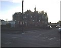
Follow that Mobile
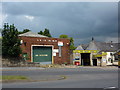
Once upon a time the building with the green door was a garage; then Sheffield City Libraries took it over as HQ for the Mobile Library Service; this has since moved on to better accommodation on Staniforth Road.
Image: © Peter Barr
Taken: 19 Jul 2011
0.17 miles
3
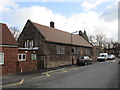
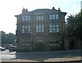
St. Joseph's Roman Catholic Primary School
Part of a group of buildings including St. Joseph's church and Presbytery. The school was designed by M. E. Hadfield and built in 1879-81 http://www.britishlistedbuildings.co.uk/en-456468-st-josephs-roman-catholic-primary-school
Image: © Jonathan Thacker
Taken: 30 Jan 2016
0.17 miles
4
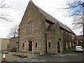
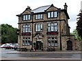
St. Joseph's Roman Catholic Church
Designed by M.E. Hadfield in 1879-81 and later extended. http://www.britishlistedbuildings.co.uk/en-456466-church-of-st-joseph-and-adjoining-prebyt#.Vqz2hNCWOTw
Image: © Jonathan Thacker
Taken: 30 Jan 2016
0.18 miles
5
Handsworth School
Taken at the Junction of St. Josephs Road and Fitzalan Road, Showing Handsworth School prior to its demolition in January 2004. The school was opened on 10th February 1902 and finally closed in 1995.
Image: © mega monty
Taken: 14 Dec 2003
0.19 miles
7
The Old Crown
One of two adjacent public houses in this Sheffield suburb. The other, to the right, is Image
Image: © Graham Hogg
Taken: 31 May 2012
0.21 miles
8
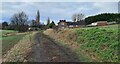
Track leading to Finchwell Road, Handsworth
Image: © Chris Morgan
Taken: 4 Jan 2021
0.21 miles
10
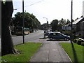
Retford Road, Handsworth
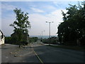
The view down Retford Road, Handsworth. Formerly known as the A57 (now B6200) prior to completion of the bypass which now skirts Mosborough and Beighton before meeting up with the M1 at Junction 31, this road is still heavily used as one of the main arterial roads into Sheffield from Woodhouse, Aston and Worksop. Just down the road on this south-east view, the road splits right to head off to Woodhouse. The photo is taken close to the (apparent) location of a milepost showing 5 miles to Sheffield and 13 to Worksop (according to the 1905 maps).
Image: © David Morris
Taken: 24 Sep 2005
0.22 miles