IMAGES TAKEN NEAR TO
Hall Road, SHEFFIELD, S13 9AG
Introduction
This page details the photographs taken nearby to Hall Road, S13 9AG by members of the Geograph project.
The Geograph project started in 2005 with the aim of publishing, organising and preserving representative images for every square kilometre of Great Britain, Ireland and the Isle of Man.

There are currently over 7.5m images from over14,400 individuals and you can help contribute to the project by visiting https://www.geograph.org.uk
Image Map
Images are licensed for reuse under creativecommons.org/licenses/by-sa/2.0
Notes
- Clicking on the map will re-center to the selected point.
- The higher the marker number, the further away the image location is from the centre of the postcode.
Image Listing (44 Images Found)
Images are licensed for reuse under creativecommons.org/licenses/by-sa/2.0
Image
Details
Distance
1
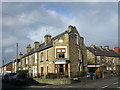
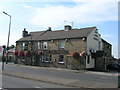
Corner house, Hendon Street
Making the most of an awkward site.
Image: © Jonathan Thacker
Taken: 30 Jan 2016
0.01 miles
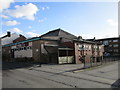
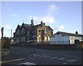
2
Handsworth School
Taken at the Junction of St. Josephs Road and Fitzalan Road, Showing Handsworth School prior to its demolition in January 2004. The school was opened on 10th February 1902 and finally closed in 1995.
Image: © mega monty
Taken: 14 Dec 2003
0.04 miles
4
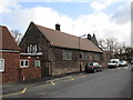
St. Joseph's Roman Catholic Primary School
Part of a group of buildings including St. Joseph's church and Presbytery. The school was designed by M. E. Hadfield and built in 1879-81 http://www.britishlistedbuildings.co.uk/en-456468-st-josephs-roman-catholic-primary-school
Image: © Jonathan Thacker
Taken: 30 Jan 2016
0.06 miles
5
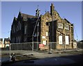
Handsworth School
Taken from over the wall in Hall Road, Showing Handsworth School prior to its demolition in January 2004. The school opened on 10th February 1902 and finally closed in 1995.
Image: © mega monty
Taken: 14 Dec 2003
0.06 miles
6
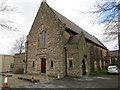
St. Joseph's Roman Catholic Church
Designed by M.E. Hadfield in 1879-81 and later extended. http://www.britishlistedbuildings.co.uk/en-456466-church-of-st-joseph-and-adjoining-prebyt#.Vqz2hNCWOTw
Image: © Jonathan Thacker
Taken: 30 Jan 2016
0.06 miles
8
Handsworth School
Taken at the Junction of Hall Road and Fitzalan Road, Showing Handsworth School prior to its demolition in January 2004. The school opened on 10th February 1902 and finally closed in 1995.
Image: © mega monty
Taken: 14 Dec 2003
0.07 miles
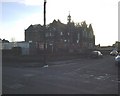
9
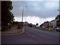
Handsworth Road, Sheffield
The B6200 road pictured here on a rain-threatened Friday afternoon in mid June. This photo shows the junction with Richmond Road on the left.
Image: © Jonathan Clitheroe
Taken: 10 Jun 2011
0.07 miles