IMAGES TAKEN NEAR TO
Normanton Spring Close, SHEFFIELD, S13 7BW
Introduction
This page details the photographs taken nearby to Normanton Spring Close, S13 7BW by members of the Geograph project.
The Geograph project started in 2005 with the aim of publishing, organising and preserving representative images for every square kilometre of Great Britain, Ireland and the Isle of Man.

There are currently over 7.5m images from over14,400 individuals and you can help contribute to the project by visiting https://www.geograph.org.uk
Image Map
Images are licensed for reuse under creativecommons.org/licenses/by-sa/2.0
Notes
- Clicking on the map will re-center to the selected point.
- The higher the marker number, the further away the image location is from the centre of the postcode.
Image Listing (14 Images Found)
Images are licensed for reuse under creativecommons.org/licenses/by-sa/2.0
Image
Details
Distance
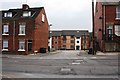
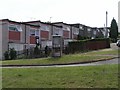
2
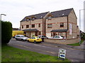
Converted School
A former primary school
Image: © Keith Pitchforth
Taken: 15 Apr 2010
0.02 miles
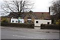
3
Netherwheel Cottages
Part of historic Normanton
Image: © Keith Pitchforth
Taken: 15 Apr 2010
0.06 miles
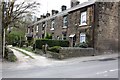
4
Former Council Housing on Normanton Grove
Image: © Keith Pitchforth
Taken: 15 Apr 2010
0.09 miles
8
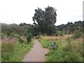
The Wickfield Plantation near Shire Brook
Path crossing the plantation from Linley Lane. This site is designated Access Land and one of the few areas of surviving lowland heath in Sheffield.
Image: © Jonathan Clitheroe
Taken: 24 Aug 2012
0.18 miles
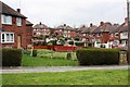
9
Houses on Scowerdons estate
Can't really say much more. This is the bottom end of Hackenthorpe, the opposite side of the Shirebrook Valley to Woodhouse and Beighton.
Image: © David Morris
Taken: 1 Jul 2006
0.21 miles
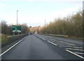
10
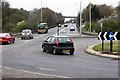
Handsworth Relief Road
Looking north towards the Sheffield Parkway
Image: © Keith Pitchforth
Taken: 15 Apr 2010
0.22 miles