IMAGES TAKEN NEAR TO
Cotleigh Road, SHEFFIELD, S12 4HY
Introduction
This page details the photographs taken nearby to Cotleigh Road, S12 4HY by members of the Geograph project.
The Geograph project started in 2005 with the aim of publishing, organising and preserving representative images for every square kilometre of Great Britain, Ireland and the Isle of Man.

There are currently over 7.5m images from over14,400 individuals and you can help contribute to the project by visiting https://www.geograph.org.uk
Image Map (Loading...)


Getting Data...Please wait
Leaflet Map data © OpenStreetMap
Images are licensed for reuse under creativecommons.org/licenses/by-sa/2.0
Notes
- Clicking on the map will re-center to the selected point.
- The higher the marker number, the further away the image location is from the centre of the postcode.
Image Listing (14 Images Found)
Images are licensed for reuse under creativecommons.org/licenses/by-sa/2.0
Image
Details
Distance
1
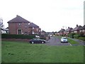
Dyke Vale Close
Local authority built housing at Hackenthorpe.
Image: © Martin Speck
Taken: 11 Aug 2009
0.11 miles
2
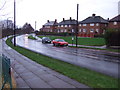
Hackenthorpe Council Housing Estate
Council houses in the rain.
Image: © John Poyser
Taken: 5 Jan 2007
0.12 miles
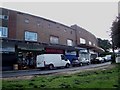
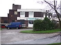
4
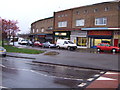
Shops at Hackenthorpe.
The shopping precinct.
Image: © John Poyser
Taken: 5 Jan 2007
0.16 miles
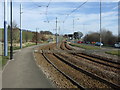
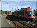
5
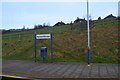
Hackenthorpe tram stop
A well-worn path down the grassy bank shows the route taken by many tram travellers from the houses above!
Image: © David Martin
Taken: 20 Feb 2015
0.21 miles
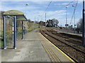
10
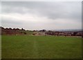
Recreation Ground in Hackenthorpe
Looking towards Hackenthorpe tram stop from a position close to Occupation Lane.
Image: © Jonathan Clitheroe
Taken: 29 Feb 2012
0.23 miles