IMAGES TAKEN NEAR TO
Church Lane, SHEFFIELD, S12 4AN
Introduction
This page details the photographs taken nearby to Church Lane, S12 4AN by members of the Geograph project.
The Geograph project started in 2005 with the aim of publishing, organising and preserving representative images for every square kilometre of Great Britain, Ireland and the Isle of Man.

There are currently over 7.5m images from over14,400 individuals and you can help contribute to the project by visiting https://www.geograph.org.uk
Image Map
Images are licensed for reuse under creativecommons.org/licenses/by-sa/2.0
Notes
- Clicking on the map will re-center to the selected point.
- The higher the marker number, the further away the image location is from the centre of the postcode.
Image Listing (8 Images Found)
Images are licensed for reuse under creativecommons.org/licenses/by-sa/2.0
Image
Details
Distance
1
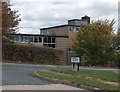
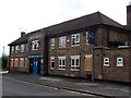
Westfield Avenue at its junction with Beighton Road
The building on the other side of Beighton Road is Rainbow Forge Primary School - on the site of the former Carter Lodge Secondary School
Image: © Neil Theasby
Taken: 21 Sep 2011
0.11 miles
4
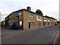
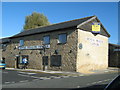
Small business units on Main Street
A development providing a mixture of office, studio, workshop and industrial space
Image: © Graham Hogg
Taken: 28 Aug 2012
0.21 miles
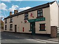
6
The Blue Bell
This pub has closed, possibly a casualty of competition from a neighbouring pub Image
Image: © Graham Hogg
Taken: 28 Aug 2012
0.24 miles
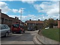
7
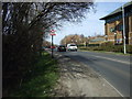
Moss Way
Heading north past Moss Way Police Station.
Image: © JThomas
Taken: 7 Mar 2015
0.24 miles
8
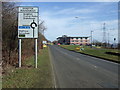
Donetsk Way
Heading north east approaching Donetsk Roundabout.
Image: © JThomas
Taken: 7 Mar 2015
0.24 miles