IMAGES TAKEN NEAR TO
Hill Turrets Close, SHEFFIELD, S11 9RF
Introduction
This page details the photographs taken nearby to Hill Turrets Close, S11 9RF by members of the Geograph project.
The Geograph project started in 2005 with the aim of publishing, organising and preserving representative images for every square kilometre of Great Britain, Ireland and the Isle of Man.

There are currently over 7.5m images from over14,400 individuals and you can help contribute to the project by visiting https://www.geograph.org.uk
Image Map (Loading...)


Getting Data...Please wait
Leaflet Map data © OpenStreetMap
Images are licensed for reuse under creativecommons.org/licenses/by-sa/2.0
Notes
- Clicking on the map will re-center to the selected point.
- The higher the marker number, the further away the image location is from the centre of the postcode.
Image Listing (27 Images Found)
Images are licensed for reuse under creativecommons.org/licenses/by-sa/2.0
Image
Details
Distance
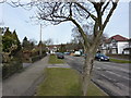
1

Bottom of Bents Road, Ecclesall, Sheffield
Image: © Peter Barr
Taken: 1 Feb 2010
0.01 miles
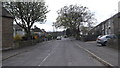
4
Top of Dobcroft Road, Ecclesall, Sheffield
Image: © Peter Barr
Taken: 1 Feb 2010
0.10 miles
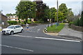
5
Broad Elms Lane, Sheffield
This road leads to Whirlow Hall Farm
Image: © Nick Morris
Taken: 17 Apr 2015
0.10 miles
6

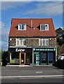
Post Office and convenience store, Parkhead
On Ecclesall Road South (A625).
Image: © JThomas
Taken: 26 Apr 2014
0.10 miles
7
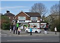
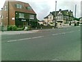
Orderly COVID 19 queue at Parkhead, Sheffield
Outside the neighbourhood's only grocery shop.
Image: © Neil Theasby
Taken: 11 Apr 2020
0.11 miles
8
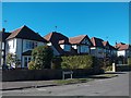
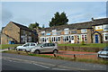
Sunny Suburbia - Bents Drive, Sheffield
Image: © Neil Theasby
Taken: 20 Oct 2010
0.11 miles