IMAGES TAKEN NEAR TO
Millhouses Lane, SHEFFIELD, S11 9HW
Introduction
This page details the photographs taken nearby to Millhouses Lane, S11 9HW by members of the Geograph project.
The Geograph project started in 2005 with the aim of publishing, organising and preserving representative images for every square kilometre of Great Britain, Ireland and the Isle of Man.

There are currently over 7.5m images from over14,400 individuals and you can help contribute to the project by visiting https://www.geograph.org.uk
Image Map
Images are licensed for reuse under creativecommons.org/licenses/by-sa/2.0
Notes
- Clicking on the map will re-center to the selected point.
- The higher the marker number, the further away the image location is from the centre of the postcode.
Image Listing (7 Images Found)
Images are licensed for reuse under creativecommons.org/licenses/by-sa/2.0
Image
Details
Distance
3
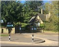
Gateway and entrance lodge at Mylnhurst School
Mylnhust is a preparatory and nursery school located in a large house dating from 1883.
Image: © Graham Hogg
Taken: 24 Apr 2020
0.18 miles
4
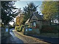
Entrance to Mylnhurst Preparatory School
In the south western suburbs of Sheffield
Image: © Neil Theasby
Taken: 4 Dec 2017
0.20 miles
5
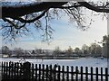
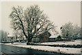
Dobcroft Infant & Junior School
Temporarily closed the day after a heavy snowfall
Image: © Graham Hogg
Taken: 15 Jan 2021
0.21 miles
6
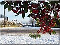
Colourful bush on Button Hill
The day after a heavy snowfall
Image: © Graham Hogg
Taken: 15 Jan 2021
0.21 miles
7
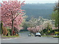
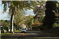
Cherry Blossom on Silverdale Road
View down Silverdale Road in Sheffield. The wooded hillside in the background is the other side of Abbeydale, one of several valleys upon which Sheffield is built.
Image: © Andrew Tryon
Taken: 22 Apr 2003
0.21 miles