IMAGES TAKEN NEAR TO
Ecclesall Road, SHEFFIELD, S11 8TB
Introduction
This page details the photographs taken nearby to Ecclesall Road, S11 8TB by members of the Geograph project.
The Geograph project started in 2005 with the aim of publishing, organising and preserving representative images for every square kilometre of Great Britain, Ireland and the Isle of Man.

There are currently over 7.5m images from over14,400 individuals and you can help contribute to the project by visiting https://www.geograph.org.uk
Image Map
Images are licensed for reuse under creativecommons.org/licenses/by-sa/2.0
Notes
- Clicking on the map will re-center to the selected point.
- The higher the marker number, the further away the image location is from the centre of the postcode.
Image Listing (121 Images Found)
Images are licensed for reuse under creativecommons.org/licenses/by-sa/2.0
Image
Details
Distance
1
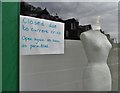
Coronavirus closure notice
In the window of a clothing shop on Ecclesall Road.
Image: © Neil Theasby
Taken: 30 Mar 2020
0.02 miles


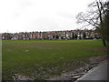
4

Edge of the Park
In Endcliffe Park, Sheffield looking to the junction of Rustlings Road and Ecclesall Road
Image: © Neil Theasby
Taken: 23 Jul 2017
0.07 miles
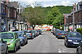
5

Endcliffe Park Vicinity, S11
The black car on the right is hovering on Rustlings Road, waiting for an opportunity to turn onto Ecclesall Road, the A625 road. The locally well-known Hunter's Bar roundabout lies 2-3 minutes walk behind the photographer, with the suburb of Banner Cross ahead. Ecclesall Road connects central Sheffield with its south western suburbs. It passes through Ecclesall and Dore and eventually leads into the Peak District National Park, via Hathersage Road. Trams used to travel along this road until 1934 (approx.).
Image: © David Hallam-Jones
Taken: 8 Apr 2014
0.07 miles
6

Hunter House Road, Sheffield
One of the city's most iconic views. Looking over the suburb of Hunters Bar towards the city centre.
Image: © Neil Theasby
Taken: 16 Feb 2019
0.08 miles
7
Sheffield - Endcliffe Park
View towards Rustlings Road.
Image: © Alan Heardman
Taken: 22 Jan 2009
0.08 miles
8
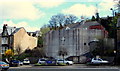
Endcliffe Park Vicinity, Sheffield 11
Designed by John Jenkinson in the 1970s, this concrete fronted church is the Trinity United Reformed Church, Ecclesall Road. Is this truly a Neo-Brutalist architectural structure, because there seems to be an older building attached to it behind? The facade was stark white when first opened in 1971. Critics of the neo-brutalist style have found it unappealing due to its cold appearance that is said to project an atmosphere of totalitarianism. Such creations were also seen as mirroring other evidence of urban decay, especially as construction materials often seemed to weather poorly in certain climates and their surfaces prone to being used for graffiti. The suburb of Hunter's Bar lies to its left and that of Banner Cross to the right.
Image: © David Hallam-Jones
Taken: 8 Apr 2014
0.08 miles
9
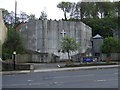
Trinity United Reformed Church
On Ecclesall Road (A625).
Image: © JThomas
Taken: 26 Apr 2014
0.08 miles
10
Looking down Ranby Road to the circus in Endcliffe Park
Image: © Neil Theasby
Taken: 10 Jun 2012
0.08 miles