IMAGES TAKEN NEAR TO
Ecclesall Road, SHEFFIELD, S11 8HF
Introduction
This page details the photographs taken nearby to Ecclesall Road, S11 8HF by members of the Geograph project.
The Geograph project started in 2005 with the aim of publishing, organising and preserving representative images for every square kilometre of Great Britain, Ireland and the Isle of Man.

There are currently over 7.5m images from over14,400 individuals and you can help contribute to the project by visiting https://www.geograph.org.uk
Image Map
Images are licensed for reuse under creativecommons.org/licenses/by-sa/2.0
Notes
- Clicking on the map will re-center to the selected point.
- The higher the marker number, the further away the image location is from the centre of the postcode.
Image Listing (85 Images Found)
Images are licensed for reuse under creativecommons.org/licenses/by-sa/2.0
Image
Details
Distance
1

The Devonshire Arms.
One of the old Wards Brewery public houses located on Ecclesall Road facing where the brewery once stood.
Image: © Mike Fowkes
Taken: 20 Jan 2006
0.02 miles
2

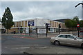
Summerfield Street
Summerfield Street looking towards the building site on Pomona Street.
Image: © Martin Speck
Taken: 20 Aug 2007
0.03 miles
3

Sunnybank nature reserve
Located on Ecclesall Road, this small reserve provides a sanctuary within the city for a variety of birds and animals.
Image: © Mike Fowkes
Taken: 20 Jan 2006
0.04 miles
4
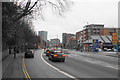
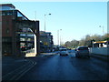
Ecclesall Road
The A625 heading towards the city centre and not far off the inner ring road.
Image: © Bill Boaden
Taken: 10 Mar 2018
0.04 miles
5
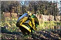
Frog public art, Sunny Bank, Sheffield
Image: © Neil Theasby
Taken: 29 Nov 2012
0.05 miles
6
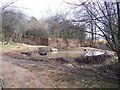
The pond at Sunnybank Nature Reserve
The pond at Sunnybank Nature Reserve during restoration work at the site.
Image: © Martin Speck
Taken: 25 Mar 2010
0.05 miles

9
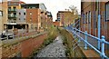
Porter Brook
The Porter Brook flows largely unseen behind high buildings and often beneath them in culverts. To the left used to be Wards Brewery, the site now redeveloped as flats.
Image: © Chris Morgan
Taken: 24 Nov 2012
0.06 miles
10
A625 at the commemorative arch to Wards Brewery
Image: © Colin Pyle
Taken: 13 Dec 2014
0.06 miles