IMAGES TAKEN NEAR TO
Cliff Street, SHEFFIELD, S11 8FA
Introduction
This page details the photographs taken nearby to Cliff Street, S11 8FA by members of the Geograph project.
The Geograph project started in 2005 with the aim of publishing, organising and preserving representative images for every square kilometre of Great Britain, Ireland and the Isle of Man.

There are currently over 7.5m images from over14,400 individuals and you can help contribute to the project by visiting https://www.geograph.org.uk
Image Map
Images are licensed for reuse under creativecommons.org/licenses/by-sa/2.0
Notes
- Clicking on the map will re-center to the selected point.
- The higher the marker number, the further away the image location is from the centre of the postcode.
Image Listing (160 Images Found)
Images are licensed for reuse under creativecommons.org/licenses/by-sa/2.0
Image
Details
Distance
3
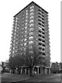
Keating Tower - social housing in Sheffield
Image: © Neil Theasby
Taken: 29 Nov 2012
0.05 miles
4
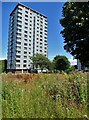
Lansdowne Meadow
With the Keating tower block beyond
Image: © Neil Theasby
Taken: 10 Aug 2021
0.05 miles
5
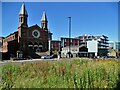
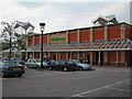
View to Cemetery Road Baptist Church
Looking across Lansdowne Meadow
Image: © Neil Theasby
Taken: 10 Aug 2021
0.05 miles

7
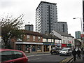
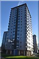
High rise in Sheffield - Mount Street flats
Three newly refurbished high rise developments off London Road.
Image: © M J Richardson
Taken: 11 Oct 2011
0.06 miles
8
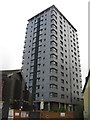
Tower block off London Road
One of three refurbished tower blocks, that now look quite smart.
Image: © M J Richardson
Taken: 11 Oct 2011
0.06 miles
9
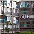
Club Garden Road Flats
Social housing from the 1960s in Sheffield
Image: © Jeanette Teare
Taken: 9 Aug 2010
0.08 miles
10
An early April walk along the London Road 51
Image: © Basher Eyre
Taken: 3 Apr 2012
0.08 miles