IMAGES TAKEN NEAR TO
Houndkirk Road, SHEFFIELD, S11 7TW
Introduction
This page details the photographs taken nearby to Houndkirk Road, S11 7TW by members of the Geograph project.
The Geograph project started in 2005 with the aim of publishing, organising and preserving representative images for every square kilometre of Great Britain, Ireland and the Isle of Man.

There are currently over 7.5m images from over14,400 individuals and you can help contribute to the project by visiting https://www.geograph.org.uk
Image Map
Images are licensed for reuse under creativecommons.org/licenses/by-sa/2.0
Notes
- Clicking on the map will re-center to the selected point.
- The higher the marker number, the further away the image location is from the centre of the postcode.
Image Listing (20 Images Found)
Images are licensed for reuse under creativecommons.org/licenses/by-sa/2.0
Image
Details
Distance
1
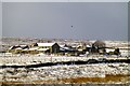
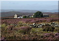
Parson House Farm
From the A6187 near Longshaw.
Image: © David Lally
Taken: 10 Mar 2013
0.02 miles
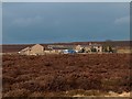
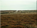
5
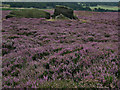
Heather moorland around Parson House
A fine day in early September with heather still well in bloom. View from Houndkirk Road (a wide rough track classified as a byway).
Image: © Andrew Hill
Taken: 6 Sep 2012
0.11 miles
6
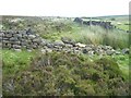
Fingerem Stone
Sidney Oldall Addy, the 19th Century historian mentions the Fingerem Stone, 'a heap of stones scattered here and there,' and links it with a nearby structure. 'The circle appears to be composed of a mixture of earth and stones, some of the stones having been lately removed for the building of walls. The circle is, as usual, incomplete, the opening pointing towards Fingerem Stone.' Fairbank's 18th Century map shows this field corner, just over the wall as the site of Fingerem Stone. Image
Image: © Martin Speck
Taken: 19 Jun 2009
0.15 miles
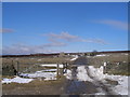
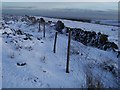
7
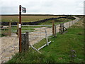
Byway, Houndkirk Moor, Sheffield
An old turnpike road now used by 4x4s.
Image: © Graham Hogg
Taken: 23 Jul 2010
0.16 miles
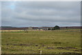
8
Burbage Moor
Looking across Burbage Moor in the direction of Parson House Farm.
Image: © Stephen Burton
Taken: 13 Aug 2014
0.20 miles
9
The site of Fingerem Stone
Sidney Oldall Addy, the 19th Century historian mentions the Fingerem Stone in connection with a nearby structure, now known as Cicely Low. Image . A map showing the location of Fingerem Stone can be found at http://en.wikipedia.org/wiki/Limb_Brook . The feature is not shown on modern maps.
Image: © Martin Speck
Taken: 31 Dec 2009
0.20 miles
10
Track to Burbage Moor
Looking north onto the moors from the A6187
Image: © Chris Shaw
Taken: Unknown
0.20 miles