IMAGES TAKEN NEAR TO
Harrison Lane, SHEFFIELD, S10 4PA
Introduction
This page details the photographs taken nearby to Harrison Lane, S10 4PA by members of the Geograph project.
The Geograph project started in 2005 with the aim of publishing, organising and preserving representative images for every square kilometre of Great Britain, Ireland and the Isle of Man.

There are currently over 7.5m images from over14,400 individuals and you can help contribute to the project by visiting https://www.geograph.org.uk
Image Map
Images are licensed for reuse under creativecommons.org/licenses/by-sa/2.0
Notes
- Clicking on the map will re-center to the selected point.
- The higher the marker number, the further away the image location is from the centre of the postcode.
Image Listing (30 Images Found)
Images are licensed for reuse under creativecommons.org/licenses/by-sa/2.0
Image
Details
Distance
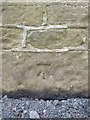
1
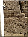
Bench Mark
This mark is on the north west corner of Bole Hill Farm
Image: © Keith Pitchforth
Taken: 22 Apr 2020
0.02 miles
2

Sunset on Christmas day
This sun is setting between the observatory to the right and the water tower of the old children's homes at Lodge Moor.
Image: © Keith Pitchforth
Taken: 25 Dec 2007
0.12 miles
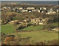
3
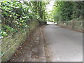
View down Harrison Lane, Sheffield
Note the lovely cobbed paving on the left.
Image: © Nick Morris
Taken: 22 Jun 2014
0.12 miles
4
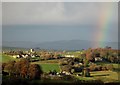
View to Lodge Moor from Ringinglow
As a rainbow finds its end over Bennet Plantation on Harrison Lane
Image: © Neil Theasby
Taken: 2 Dec 2016
0.12 miles
6
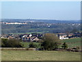
View from Blackbrook Road
Over fields and houses to the west of Sheffield with the city centre in the distance.
Image: © Graham Hogg
Taken: 18 Mar 2011
0.14 miles
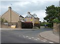
7
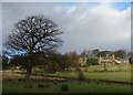
Fulwood Hall seen from Mayfield Road
A hall existed on the site of the current Fulwood Hall in the late fifteenth century, as it was mentioned in deeds from the reign of Henry VII (1485 to 1509). The owners at that time were the Fox family who held considerable possessions throughout the townships of Upper Hallam and Bradfield.
Image: © Neil Theasby
Taken: 7 Jan 2014
0.14 miles
8
Bench Mark
This mark is at 879.9 feet (from OS Six inch series revised 1914-1915 but not published until 1924)
Image: © Keith Pitchforth
Taken: 22 Apr 2020
0.14 miles
9
Fulwood Hall on Harrison Lane viewed from Ringinglow
To see the Wikipedia page devoted to historic Fulwood Hall, go here: https://en.wikipedia.org/wiki/Fulwood_Hall
Image: © Neil Theasby
Taken: 2 Dec 2016
0.15 miles
10
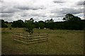
Mayfield Valley
View over Michael Willson's grave, with new fence to protect the apple tree from the horses.
Image: © Lera Miles
Taken: 18 Jul 2005
0.16 miles