IMAGES TAKEN NEAR TO
Moorcroft Avenue, SHEFFIELD, S10 4GT
Introduction
This page details the photographs taken nearby to Moorcroft Avenue, S10 4GT by members of the Geograph project.
The Geograph project started in 2005 with the aim of publishing, organising and preserving representative images for every square kilometre of Great Britain, Ireland and the Isle of Man.

There are currently over 7.5m images from over14,400 individuals and you can help contribute to the project by visiting https://www.geograph.org.uk
Image Map
Images are licensed for reuse under creativecommons.org/licenses/by-sa/2.0
Notes
- Clicking on the map will re-center to the selected point.
- The higher the marker number, the further away the image location is from the centre of the postcode.
Image Listing (20 Images Found)
Images are licensed for reuse under creativecommons.org/licenses/by-sa/2.0
Image
Details
Distance
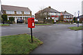
1
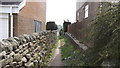
Public footpath
Path connects Moorcroft Drive with School Green Lane
Image: © Nick Morris
Taken: 16 Apr 2015
0.06 miles
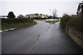
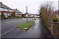
2
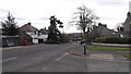
Crimicar Lane, Sheffield
Looking down Crimicar Lane from the corner of Moorcroft Road
Image: © Nick Morris
Taken: 14 Apr 2015
0.09 miles
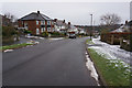
3
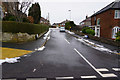
Brooklands Drive off Brooklands Avenue, Sheffield
Image: © Ian S
Taken: 20 Jan 2018
0.13 miles
5
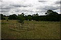
Mayfield Valley
View over Michael Willson's grave, with new fence to protect the apple tree from the horses.
Image: © Lera Miles
Taken: 18 Jul 2005
0.14 miles
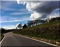
7
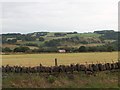
Mayfield Valley from School Green Lane, Fulwood
Image: © Neil Theasby
Taken: 1 Aug 2010
0.15 miles